

 South Florida will be hot and mostly storm-free on Labor Day, but our big concern is the future track of Hurricane Irma. At 5 am Monday, Irma was located near 16.9 North, 52.3 West, and was moving west-southwest at 14 miles per hour. Maximum sustained winds were 115 miles per hour, but Irma is expected to strengthen (and may already have done so, based on satellite images from early Monday).
 Irma will be in or near portions of the Lesser Antilles by late Tuesday, and hurricane warnings are up. Computer model runs have shifted westward and indicate that the trough that could have allowed Irma to turn soon enough to turn well east of the U.S. coast is not likely to be strong enough to do so.
Additional data from reconnaissance flights into Irma will sharpen the picture. But right now, we have to be aware that a major hurricane could affect our weather by next weekend.
It’s time to think about what you need to do to get ready if we feel the fringes of the system — or worse.

Take some time on the holiday to do those things that you’d need to do (especially getting supplies or gassing up your car) before the rush begins. It’s also a good idea to check your shutters and make sure you have all the hardware you need — just in case we’ll need to put up shutters later.
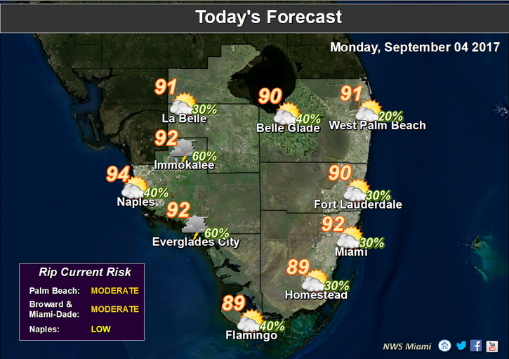 Labor Day should be a good day for any outdoor activities, but it will be hot. Look for a quick early shower in spots, hot and some clouds, a moderate risk of dangerous rip currents at the Atlantic beaches, and just a stray storm in the afternoon, as the sea breeze pushes most of the activity well inland. Highs on Monday will be in the low 90s.
 Tuesday will bring a few early showers, sun and clouds, and some afternoon storms in spots. Tuesday’s highs will be in the low 90s.
Wednesday will see more of the same — a few morning showers, sun and clouds, and afternoon storms along the sea breeze. Wednesday’s highs will be in the low 90s.
Look for passing showers and storms on Thursday, with some periods of sun. Highs on Thursday will be in the low 90s.
Friday’s forecast will depend on the track of Hurricane Irma, but for now we’ll say that it will feature plenty of clouds and passing showers and storms. Friday’s highs will be in the low 90s.
Disclaimer
Artificial Intelligence Disclosure & Legal Disclaimer
AI Content Policy.
To provide our readers with timely and comprehensive coverage, South Florida Reporter uses artificial intelligence (AI) to assist in producing certain articles and visual content.
Articles: AI may be used to assist in research, structural drafting, or data analysis. All AI-assisted text is reviewed and edited by our team to ensure accuracy and adherence to our editorial standards.
Images: Any imagery generated or significantly altered by AI is clearly marked with a disclaimer or watermark to distinguish it from traditional photography or editorial illustrations.
General Disclaimer
The information contained in South Florida Reporter is for general information purposes only.
South Florida Reporter assumes no responsibility for errors or omissions in the contents of the Service. In no event shall South Florida Reporter be liable for any special, direct, indirect, consequential, or incidental damages or any damages whatsoever, whether in an action of contract, negligence or other tort, arising out of or in connection with the use of the Service or the contents of the Service.
The Company reserves the right to make additions, deletions, or modifications to the contents of the Service at any time without prior notice. The Company does not warrant that the Service is free of viruses or other harmful components.


