

Friday features a mix of hot sun, clouds, showers, and mainly afternoon and evening storms on the mainland. The Keys will be mostly sunny with a stray shower in spots. A high risk of dangerous rip currents remains at the Atlantic beaches through Saturday afternoon. Highs on Friday will be mostly in the mid-90s in the East Coast metro area and mostly in the low-90s along the Gulf Coast and the Keys — but it will feel at least 10 degrees hotter everywhere, so stay hydrated and out of the sun.
Saturday will bring mostly sunny skies alternating with periods of showers and storms. Heavy rain is possible in spots. Look for storms to linger into the evening on the East Coast metro area. The Keys will see a mix of sun, clouds, and some showers. Saturday’s highs will be mostly in the mid-90s in the East Coast metro area and the low-90s along the Gulf Coast and the Keys.
Sunday will feature a mix of sun, showers, and storms on the mainland, while the Keys will see mostly sunny skies. Sunday’s highs will be mostly in the mid-90s in the East Coast metro area and in the low 90s along the Gulf coast and in the Keys.
Monday will be another hot day of sun, showers, and storms on the mainland. Look for a mix of sun and clouds in the Keys. Monday’s highs will be mostly in the mid 90s in the east coast metro area and in the low-90s along the Gulf Coast and the Keys.

Tuesday’s forecast calls for a late August mix of sun, showers, and storms on the mainland, while the Keys will be mostly sunny. Highs on Tuesday will be mostly in the mid-90s in the East Coast metro area and the low-90s along the Gulf Coast and the Keys.

Hurricane Erin is moving away more quickly, but its effects are still being felt up and down the US east coast. Rough surf and high waves from Erin have the potential for coastal flooding and beach erosion, and rip currents caused by the hurricane are potentially deadly.
On Thursday evening, Erin was located about 420 miles east-northeast of Cape Hatteras, North Carolina and 365 miles north-northwest of Bermuda. Maximum sustained winds were 100 miles per hour, and Erin was moving northeast at 20 miles per hour at that time. A storm surge warning remains in effect from Cape Lookout to Duck, North Carolina, and a tropical storm warning remains for Bermuda.
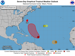 Elsewhere in the tropics, we’re keeping an eye on 3 features. First, the wave in the central Atlantic has a high chance of becoming a depression as it nears the Leeward Islands. This feature is forecast to turn northward and stay far from the US coast. The second is the wave in the eastern Atlantic that has a rapidly closing window of opportunity for development before en
Disclaimer
Artificial Intelligence Disclosure & Legal Disclaimer
AI Content Policy.
To provide our readers with timely and comprehensive coverage, South Florida Reporter uses artificial intelligence (AI) to assist in producing certain articles and visual content.
Articles: AI may be used to assist in research, structural drafting, or data analysis. All AI-assisted text is reviewed and edited by our team to ensure accuracy and adherence to our editorial standards.
Images: Any imagery generated or significantly altered by AI is clearly marked with a disclaimer or watermark to distinguish it from traditional photography or editorial illustrations.
General Disclaimer
The information contained in South Florida Reporter is for general information purposes only.
South Florida Reporter assumes no responsibility for errors or omissions in the contents of the Service. In no event shall South Florida Reporter be liable for any special, direct, indirect, consequential, or incidental damages or any damages whatsoever, whether in an action of contract, negligence or other tort, arising out of or in connection with the use of the Service or the contents of the Service.
The Company reserves the right to make additions, deletions, or modifications to the contents of the Service at any time without prior notice. The Company does not warrant that the Service is free of viruses or other harmful components.


