

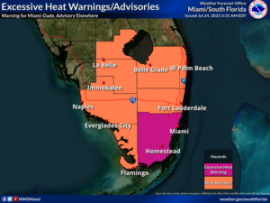
 Monday features lots of very hot and hazy sun as our stretch of dangerously hot weather continues. An excessive heat warning is in effect for Miami-Dade from 10 am to 8 pm on Monday. The heat advisory continues for the rest of South Florida on Monday, and it’s been extended for all of South Florida until at least Tuesday evening. Highs on Monday will be in the mid-90s right at the coasts and in portions of the Keys, but elsewhere in South Florida, we’ll reach the upper 90s — and are expected to break some records. And it will feel at least 10 degrees hotter, so stay hydrated and out of the sun.
LIVE RADAR 24/7 (Click Here Then Press Play)
Tuesday will bring mostly sunny skies with storms developing in the afternoon and tapering off in the evening. Tuesday’s highs will be in the mid-90s in the east coast metro area and the Keys and in the upper 90s along the Gulf Coast and in the interior.
Wednesday will feature a mix of sun, clouds, and maybe a storm in the morning. Showers will move in during the afternoon, and we’ll see some storms in the evening. Wednesday’s highs will be mostly in the steamy low 90s in the east coast metro area and in the mid-90s along the Gulf Coast and in the Keys.

Thursday will see some sun, more clouds, and plenty of showers with a storm or two in spots. Thursday’s highs will be in the low 90s in the east coast metro area and the mid-90s along the Gulf Coast.
Friday’s forecast calls for clouds, showers, and storms. Highs on Friday will be in the humid mid-90s.
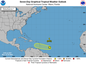 In the tropics, the wave in the central Atlantic now has only a low chance of becoming a depression before reaching portions of the Lesser Antilles later this week. After that, this wave will encounter hostile conditions in the Caribbean. Elsewhere, Don briefly became a hurricane on Saturday but has weakened to tropical storm strength again.. Since it’s moving into an area of cooler waters in the middle of the Atlantic, Don is forecast to lose its tropical characteristics on Monday and dissipate (finally) on Tuesday.
Disclaimer
Artificial Intelligence Disclosure & Legal Disclaimer
AI Content Policy.
To provide our readers with timely and comprehensive coverage, South Florida Reporter uses artificial intelligence (AI) to assist in producing certain articles and visual content.
Articles: AI may be used to assist in research, structural drafting, or data analysis. All AI-assisted text is reviewed and edited by our team to ensure accuracy and adherence to our editorial standards.
Images: Any imagery generated or significantly altered by AI is clearly marked with a disclaimer or watermark to distinguish it from traditional photography or editorial illustrations.
General Disclaimer
The information contained in South Florida Reporter is for general information purposes only.
South Florida Reporter assumes no responsibility for errors or omissions in the contents of the Service. In no event shall South Florida Reporter be liable for any special, direct, indirect, consequential, or incidental damages or any damages whatsoever, whether in an action of contract, negligence or other tort, arising out of or in connection with the use of the Service or the contents of the Service.
The Company reserves the right to make additions, deletions, or modifications to the contents of the Service at any time without prior notice. The Company does not warrant that the Service is free of viruses or other harmful components.


