

Thursday features some sun, morning showers, and plenty of afternoon storms in the East Coast metro area. The Gulf coast will be mostly sunny in the morning, but showers and storms will develop in the afternoon and linger into the evening. The Keys will be mostly cloudy with periods of showers and storms. Expect coastal flooding near high tides, especially along the Atlantic coast and in the Keys. A high risk of dangerous rip currents continues along the Palm Beach County coast, and there’s a moderate rip current risk at the Broward and Miami-Dade beaches. Highs on Thursday will be mostly in the mid-80s in the East Coast metro area and the Keys and near 90 degrees along the Gulf coast.
Friday will bring clouds and showers to the East Coast metro area, while the Gulf Coast will see clouds and a few early showers followed by periods of storms in the afternoon and early evening. Look for clouds and showers in the Keys. Friday’s highs will be in the mid-80s in the East Coast metro area and the Keys and in the upper 80s along the Gulf Coast.
Saturday will feature sun and clouds with periods of showers and storms in the East Coast metro area as a weak front moves through. The Gulf Coast and the Keys will be mostly sunny. Saturday’s highs will be in the mid-80s.
Sunday will see lots of sun along the Gulf Coast and in the Keys, while the East Coast metro area will be sunny most of the day with a few afternoon showers and storms in spots. Sunday’s highs will be mostly in the mid-80s.

The forecast for Columbus Day/Indigenous Peoples’ Day calls for lots of sun and a cloud or two at times. Highs on Monday will be mostly in the upper 80s.
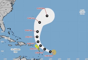 In the tropics, Tropical Storm Jerry continues moving quickly to the west-northwest. On Wednesday evening, TS Jerry was about 605 miles east-southeast of the northern Leeward Islands and was moving west-northwest at 23 miles per hour. Maximum sustained winds were 60 miles per hour, and strengthening is forecast. There are tropical storm watches for Antigua, Barbuda, Anguilla, St. Kitts, Nevis, Montserrat, St. Barthelemy and St. Martin, Sint Maarten, Saba and St. Eustatius, and Guadeloupe and the adjacent islands.
Jerry is forecast to become a hurricane on Friday as it turns to the north, which will keep it east of the Bahamas.
Elsewhere, the area of low pressure in the Bay of Campeche is coming ashore in Mexico. It is unlikely to become a depression, but it will bring heavy rain to portions of Mexico and the Yucatan.
Disclaimer
The information contained in South Florida Reporter is for general information purposes only.
The South Florida Reporter assumes no responsibility for errors or omissions in the contents of the Service.
In no event shall the South Florida Reporter be liable for any special, direct, indirect, consequential, or incidental damages or any damages whatsoever, whether in an action of contract, negligence or other tort, arising out of or in connection with the use of the Service or the contents of the Service. The Company reserves the right to make additions, deletions, or modifications to the contents of the Service at any time without prior notice.
The Company does not warrant that the Service is free of viruses or other harmful components


