

Monday features a gusty breeze and a mix of sun and clouds with periods of showers and storms, especially in the afternoon in the east coast metro area and from mid-afternoon through the evening along the Gulf coast. The Keys will see plenty of clouds and periods of showers. A high risk of dangerous rip currents is in place at the Atlantic beaches on Monday and Tuesday. Highs on Monday will be in the upper 80s right at the Atlantic coast and in the Keys, while the rest of South Florida will reach the low 90s. But it will feel about 10 degrees hotter along the Gulf coast and in the interior.
Tuesday will bring mostly sunny skies, a gusty breeze, and plenty of showers and storms to the mainland. The Keys will see a mix of sun, clouds, and a few showers. Expect an elevated risk of dangerous rip currents at the Atlantic beaches. Tuesday‘s highs will be near 90 degrees in the east coast metro area, in the low 90s along the Gulf coast, and in the upper 80s in the Keys.
Wednesday will feature sun, clouds, and periods of showers and storms on the mainland, especially in the afternoon and early evening. The Keys will see mostly sunny skies. Wednesday‘s highs will be mostly in the low 90s on the mainland and in the upper 80s in the Keys.
Thursday will see a mix of hot sun, some clouds, and plenty of afternoon showers and storms on the mainland. Look for good sun, a few clouds, and maybe a shower in the Keys. Thursday‘s highs will be mostly in the low 90s on the mainland and in the upper 80s in the Keys.
Friday’s forecast calls for mostly sunny skies, with plenty of showers and storms on the mainland. Highs on Friday will be mostly in the low 90s in the east coast metro area and in the upper 80s along the Gulf coast and in the Keys.
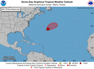 In the tropics, a trough of low pressure several hundred miles east of Bermuda is producing some disorganized showers and storms. The National Hurricane Center says this feature currently has a high chance of becoming a subtropical or tropical depression on Monday, but conditions should be unfavorable for development beginning on Tuesday.
Disclaimer
The information contained in South Florida Reporter is for general information purposes only.
The South Florida Reporter assumes no responsibility for errors or omissions in the contents of the Service.
In no event shall the South Florida Reporter be liable for any special, direct, indirect, consequential, or incidental damages or any damages whatsoever, whether in an action of contract, negligence or other tort, arising out of or in connection with the use of the Service or the contents of the Service. The Company reserves the right to make additions, deletions, or modifications to the contents of the Service at any time without prior notice.
The Company does not warrant that the Service is free of viruses or other harmful components


