As October comes to a close, a dynamic weather pattern is bringing dramatic contrasts across the United States. Forecasters at AccuWeather are monitoring an array of hazards, ranging from tropical downpours in the Pacific to disruptive Halloween storms and a lingering eastern drought. Meanwhile, millions of residents are preparing to turn their clocks back as daylight saving time concludes.
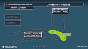 In the central Pacific, Hawaii continues to endure dangerous flash flooding and mudslides produced by Tropical Rainstorm Olana. Although Olana sits well southwest of the islands over open water, its deep tropical moisture is battering the state through Thursday night. According to AccuWeather, eastern Kaua’i through the Big Island can expect 1 to 2 inches of rain. Higher terrain across Maui and the Big Island faces 4 to 8 inches, with an AccuWeather Local StormMax™ of 30 inches in isolated spots. These torrential downpours threaten to wash out roads, flood poor drainage areas, and trigger mudslides across steep terrain.
Olana is the latest system in an unprecedented string of tropical threats this season, following Moke, Nolo, Lala, and Lowell. A strengthening El Niño has fueled this unusually active Pacific pattern. Historically, storms approaching Hawaii from the west or southwest before turning northeastward are rare, echoing the path of Hurricane Iwa during the strong El Niño of November 1982. Forecasters are also watching a medium-risk development zone southeast of the islands between Nov. 3 and Nov. 6.

“After days of heavy rainfall from Olana, another tropical system is developing in the Pacific,” said AccuWeather Lead Hurricane Expert Alex DaSilva. “Hawaii has already experienced an active tropical season, and additional rainfall could worsen flooding and complicate recovery efforts. At this point, it looks like any developing storm would likely track south of the islands. However, this needs to be monitored closely as even a close pass could still bring rain impacts. We are closely monitoring this new development area to determine whether it could bring another round of hazardous weather to the islands.”
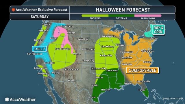
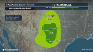 On the mainland, weather trouble spots are emerging just in time for Halloween on Saturday, Oct. 31. AccuWeather meteorologists warn that Texas and the Central Plains face the highest risk for disrupted trick-or-treating. Heavy downpours and thunderstorms could trigger localized flash flooding and hazardous travel in major hubs like Houston and San Antonio.
“Halloween is one of those nights when millions of families are outside at the same time, so the timing of the weather really matters,” said AccuWeather Expert Meteorologist Tyler Roys. “A thunderstorm that lasts just 30 minutes can disrupt an entire evening of trick-or-treating. Families in areas expecting storms should have a backup plan and be ready to move celebrations indoors if conditions become dangerous.”
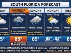
Elsewhere in the West, showers could dampen Saturday festivities in Los Angeles and San Diego. A separate surge of tropical moisture will bring frequent downpours from Saturday night through Sunday night across Arizona, Utah, and southwestern Colorado. Forecasters warn of flash flooding and debris flows near Phoenix, Tucson, Flagstaff, Cedar City, Moab, and Durango. Farther north, chilly AccuWeather RealFeel® Temperatures in the 30s and 40s will force families to bundle up across Washington, Oregon, Idaho, Montana, and Wyoming. Spotty rain may also interrupt plans in Florida and the Pacific Northwest.
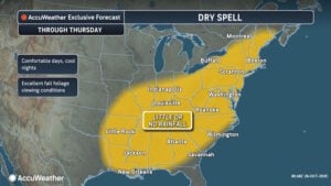 In contrast, much of the eastern United States will enjoy mild, dry Halloween weather, with temperatures running several degrees above historical averages from northern Florida to the Great Lakes. However, that pleasant autumn warmth masks a severe moisture deficit. If measurable rain arrives as forecast on Monday, Nov. 2, it will break the longest dry spell since fall 2024 for New York City and Philadelphia, and the longest since early 2026 for Washington, D.C., and Raleigh.
“This is a remarkable stretch of dry weather affecting millions of people across the eastern United States. Some cities have gone more than three weeks without measurable rainfall, and the dry spell is expected to continue across a large area through Thursday,” said AccuWeather Expert Meteorologist Alan Reppert. “While the comfortable afternoons and cool nights are ideal for enjoying fall foliage, the lack of rainfall is becoming an increasing concern.”
Depleted soil moisture and carpets of dry leaves have elevated brush fire dangers during gusty, low-humidity afternoons.
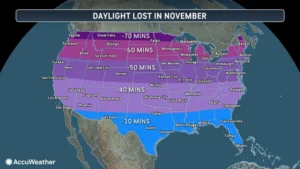 Before the rain arrives Monday, most Americans will experience an abrupt shift in daylight. Daylight saving time ends at 2 a.m. local time on Sunday, Nov. 1, the earliest possible calendar date for the transition. While Hawaii and most of Arizona abstain from changing clocks, millions of residents in New York City, Chicago, Denver, Los Angeles, and Seattle will see the sun set before 5 p.m. Sunday. Caribou, Maine, faces an early sunset at 4:16 p.m., whereas Miami and Houston hold onto evening light past 5:30 p.m.
“The time change can really catch people off guard, especially when they’re leaving work or picking up their kids and suddenly find themselves doing those activities after sunset,” Roys explained. “While we aren’t actually losing an hour of daylight when the clocks change, shifting that daylight to the morning can make evenings feel much shorter.”
Sources
Disclaimer
Artificial Intelligence Disclosure & Legal Disclaimer
AI Content Policy.
To provide our readers with timely and comprehensive coverage, South Florida Reporter uses artificial intelligence (AI) to assist in producing certain articles and visual content.
Articles: AI may be used to assist in research, structural drafting, or data analysis. All AI-assisted text is reviewed and edited by our team to ensure accuracy and adherence to our editorial standards.
Images: Any imagery generated or significantly altered by AI is clearly marked with a disclaimer or watermark to distinguish it from traditional photography or editorial illustrations.
General Disclaimer
The information contained in South Florida Reporter is for general information purposes only.
South Florida Reporter assumes no responsibility for errors or omissions in the contents of the Service. In no event shall South Florida Reporter be liable for any special, direct, indirect, consequential, or incidental damages or any damages whatsoever, whether in an action of contract, negligence or other tort, arising out of or in connection with the use of the Service or the contents of the Service.
The Company reserves the right to make additions, deletions, or modifications to the contents of the Service at any time without prior notice. The Company does not warrant that the Service is free of viruses or other harmful components.