

 Sea breeze showers and storms are in the forecast for South Florida on Friday. The day features a mix of sun and clouds with mid to late afternoon showers and storms forming along the sea breezes. Most of the activity with be in western portions of the east coast metro area and in the interior. Highs on Friday will be in the low 90s, but it will feel quite a bit hotter.
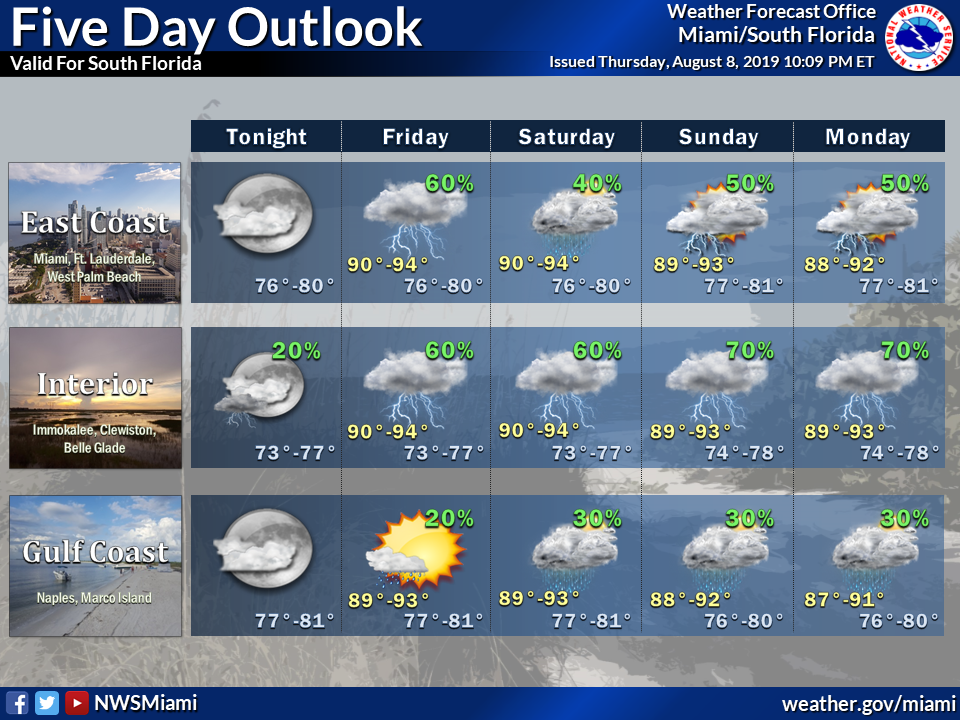 Saturday will bring higher rain chances, especially in the east coast metro area during the afternoon. Saturday’s highs will be near 90 degrees.
Sunday will feature sun, clouds, and passing showers and storms in spots. Sunday’s highs will be in the low 90s.
Look for a mix of sun and clouds with periods of showers and storms on Monday. Monday’s highs will be in the low 90s.

Tuesday’s forecast includes sun, clouds, and passing showers and storms. Highs on Tuesday will be near 90 degrees.
The tropical Atlantic remains quiet right now. However, NOAA forecasters monitoring oceanic and atmospheric patterns say conditions are now more favorable for above-normal hurricane activity since El Nino has now ended. Two named storms have formed so far this year and the peak months of the hurricane season, August through October, are now underway. We’ll keep an eye on things.
Disclaimer
The information contained in South Florida Reporter is for general information purposes only.
The South Florida Reporter assumes no responsibility for errors or omissions in the contents of the Service.
In no event shall the South Florida Reporter be liable for any special, direct, indirect, consequential, or incidental damages or any damages whatsoever, whether in an action of contract, negligence or other tort, arising out of or in connection with the use of the Service or the contents of the Service. The Company reserves the right to make additions, deletions, or modifications to the contents of the Service at any time without prior notice.
The Company does not warrant that the Service is free of viruses or other harmful components


