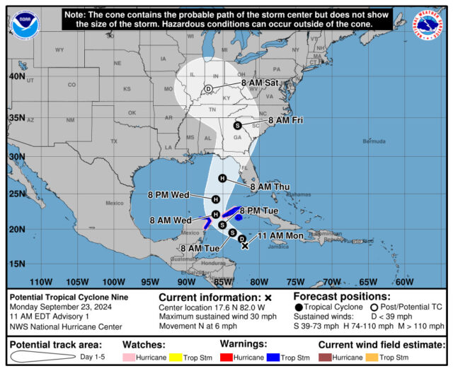
The area of disturbed weather in the western Caribbean that we’ve been watching for several days is now Potential Tropical Cyclone # 9 — and portions of Florida are in the cone.
At 11 am Monday, Potential TC # 9 was located near 17.6 North, 82.0 West, about 350 miles south-southeast of the western tip of Cuba. Maximum sustained winds were 30 miles per hour, and Potential TC # 9 was moving north at 6 miles per hour.

There’s a tropical storm warning for parts of the Yucatan and for western Cuba, including Pinar del Rio, Artemisa, and the Isle of Youth (Isle of Pines). Up to 12 inches of rain and flash flooding are possible in the warning areas, and up to 6 inches of rain are possible in the Cayman Islands.
Potential TC # 9 is expected to become a hurricane before landfall, which looks to be in northern Florida sometime on Thursday afternoon. Watches and warnings are likely on Tuesday. Remember, computer models are not infallible, especially with a system that does not yet have a closed circulation. Everyone in South Florida (and the whole state, for that matter), should keep a very close eye on Potential TC # 9.
Disclaimer
Artificial Intelligence Disclosure & Legal Disclaimer
AI Content Policy.
To provide our readers with timely and comprehensive coverage, South Florida Reporter uses artificial intelligence (AI) to assist in producing certain articles and visual content.
Articles: AI may be used to assist in research, structural drafting, or data analysis. All AI-assisted text is reviewed and edited by our team to ensure accuracy and adherence to our editorial standards.
Images: Any imagery generated or significantly altered by AI is clearly marked with a disclaimer or watermark to distinguish it from traditional photography or editorial illustrations.
General Disclaimer
The information contained in South Florida Reporter is for general information purposes only.
South Florida Reporter assumes no responsibility for errors or omissions in the contents of the Service. In no event shall South Florida Reporter be liable for any special, direct, indirect, consequential, or incidental damages or any damages whatsoever, whether in an action of contract, negligence or other tort, arising out of or in connection with the use of the Service or the contents of the Service.
The Company reserves the right to make additions, deletions, or modifications to the contents of the Service at any time without prior notice. The Company does not warrant that the Service is free of viruses or other harmful components.


