

Monday features mostly sunny skies and a gusty ocean breeze. A shower is possible in parts of the East Coast metro area. Minor flooding at high tides is possible at the Atlantic coast. A high risk of dangerous rip currents remains at the Atlantic beaches through Tuesday evening. Highs on Monday will be in the mid-80s.
Tuesday will bring plenty of sun and a gusty breeze to the mainland, but a few afternoon showers will also develop in the East Coast metro area. The Keys will see a mix of sun and clouds. Tuesday’s highs will be mostly in the mid-80s.
Wednesday will feature a sunny morning, a gusty breeze, and a few afternoon showers in the East Coast metro area. The Gulf Coast will see lots of sun, while the Keys will be mostly sunny. Wednesday’s highs will be in the mid-80s on the mainland and mostly in the low 80s in the Keys.
Thursday will continue the pattern: lots of sun on the mainland, a few East Coast showers in the afternoon, and a mix of sun and clouds in the Keys. Thursday’s highs will be in the mid-80s on the mainland and mostly in the low 80s in the Keys.

Friday’s forecast calls for lots of sun, a few clouds, and maybe a stray East Coast shower. Highs on Friday will be mostly in the mid-80s.
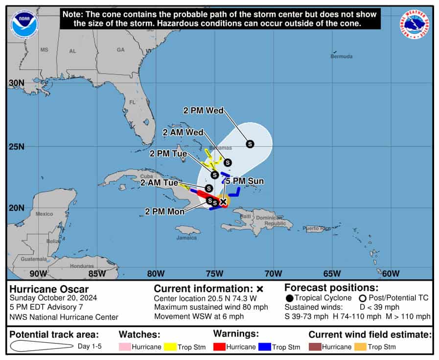 In the tropics, Hurricane Oscar was approaching landfall in northeastern Cuba Sunday evening. At that time, Oscar’s maximum sustained winds were 80 miles per hour, and the hurricane was moving west-southwest at 6 miles per hour. Oscar is forecast to weaken to a tropical storm and then turn to the northeast on Monday. There is a tropical storm warning for both the central and southeastern Bahamas. No watches or warnings are expected for either South Florida or the northwestern Bahamas.
 Elsewhere, Nadine has dissipated over Central America. Its remnants will move into the eastern Pacific, where regeneration is expected (but with a different name). But flash flooding from heavy rain continues to be a threat to Belize and portions of Mexico and Guatemala.
Disclaimer
Artificial Intelligence Disclosure & Legal Disclaimer
AI Content Policy.
To provide our readers with timely and comprehensive coverage, South Florida Reporter uses artificial intelligence (AI) to assist in producing certain articles and visual content.
Articles: AI may be used to assist in research, structural drafting, or data analysis. All AI-assisted text is reviewed and edited by our team to ensure accuracy and adherence to our editorial standards.
Images: Any imagery generated or significantly altered by AI is clearly marked with a disclaimer or watermark to distinguish it from traditional photography or editorial illustrations.
General Disclaimer
The information contained in South Florida Reporter is for general information purposes only.
South Florida Reporter assumes no responsibility for errors or omissions in the contents of the Service. In no event shall South Florida Reporter be liable for any special, direct, indirect, consequential, or incidental damages or any damages whatsoever, whether in an action of contract, negligence or other tort, arising out of or in connection with the use of the Service or the contents of the Service.
The Company reserves the right to make additions, deletions, or modifications to the contents of the Service at any time without prior notice. The Company does not warrant that the Service is free of viruses or other harmful components.


")
")