

Monday features mostly sunny skies around South Florida. Expect an increasing risk of dangerous rip currents at the Atlantic beaches on Monday and beyond. Highs on Monday will be in the mid-80s in the East Coast metro area and the Keys and in the upper 80s along the Gulf Coast.
Tuesday will bring sun, clouds, a gusty breeze, and a few east coast showers in spots. Tuesday’s highs will be in the mid-80s in the East Coast metro area and the Keys and in the upper 80s along the Gulf Coast.
Wednesday will feature breezy conditions, plenty of sun, and a few clouds at times. Wednesday’s highs will be in the mid-80s in the East Coast metro area and the Keys and in the upper 80s along the Gulf Coast.
Thursday will be a breezy and sunny day around South Florida. Thursday’s highs will be in the mid-80s in the East Coast metro area and the Keys and in the upper 80s along the Gulf Coast.

Friday’s forecast calls for lots of sun again. Look for breezy conditions in the east coast metro area. Highs on Friday will once again be in the mid 80s in the East Coast metro area and the Keys and in the upper 80s along the Gulf Coast.
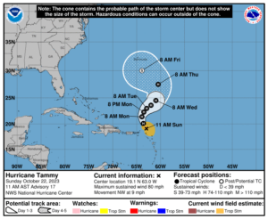 In the tropics, Hurricane Tammy is moving away from the Leeward Islands, but we’ll have to keep a very close eye on what happens later this week. While Tammy is expected to move to the north and then northeast as it interacts with a trough on Monday and Tuesday, it appears that that won’t be enough to scoop the hurricane up and accelerate it into the middle of the Atlantic. Instead, the future track of Tammy is unclear, even as it is expected to weaken. Bermuda could see significant impacts from Tammy on Friday, and an eventual landfall somewhere along the southeast coast of the U.S. is not out of the question. It’s another reminder that the hurricane season isn’t over yet.
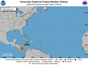 Elsewhere, the area of disturbed weather in the extreme southwestern Caribbean has a medium chance of becoming a depression before it reaches the coast of Nicaragua on Tuesday. Whether it becomes a depression or not, this system will bring heavy rain to portions of Central America.
Disclaimer
Artificial Intelligence Disclosure & Legal Disclaimer
AI Content Policy.
To provide our readers with timely and comprehensive coverage, South Florida Reporter uses artificial intelligence (AI) to assist in producing certain articles and visual content.
Articles: AI may be used to assist in research, structural drafting, or data analysis. All AI-assisted text is reviewed and edited by our team to ensure accuracy and adherence to our editorial standards.
Images: Any imagery generated or significantly altered by AI is clearly marked with a disclaimer or watermark to distinguish it from traditional photography or editorial illustrations.
General Disclaimer
The information contained in South Florida Reporter is for general information purposes only.
South Florida Reporter assumes no responsibility for errors or omissions in the contents of the Service. In no event shall South Florida Reporter be liable for any special, direct, indirect, consequential, or incidental damages or any damages whatsoever, whether in an action of contract, negligence or other tort, arising out of or in connection with the use of the Service or the contents of the Service.
The Company reserves the right to make additions, deletions, or modifications to the contents of the Service at any time without prior notice. The Company does not warrant that the Service is free of viruses or other harmful components.


