

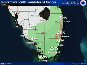
 Monday features mostly sunny skies around South Florida, but we can’t rule out an afternoon shower in spots in the east coast metro area. A high risk of dangerous rip currents remains along the Atlantic coast through at least Monday morning. Minor flooding near high tide is possible along the east coast until Monday afternoon. Highs on Monday will be in the mid-80s in the East Coast metro area and the Keys and in the upper 80s along the Gulf Coast.
Halloween will bring a mix of sun, clouds, and showers to the East Coast metro area, while the Gulf Coast will be sunny. Some scary showers will linger in the evening near the East Coast, but the Gulf Coast should be mostly dry and ghoulish for trick-or-treating. Tuesday’s highs will be in the mid-80s right at the Atlantic coast and in the Keys and the upper 80s elsewhere in South Florida.
Wednesday will feature breezy conditions, a mix of sun and clouds, and some afternoon and evening showers in the east coast metro area. The Gulf Coast will be sunny with a gusty breeze. Wednesday’s highs will be in the mid-80s.
Thursday will be windy with periods of showers in the east coast metro area. Look for lots of sun and breezy conditions along the Gulf Coast. Thursday’s highs will be mostly in the low 80s.

Friday’s forecast calls for a windy day with sun, clouds, and a few showers in the east coast metro area. Breezy conditions and lots of sun will prevail along the Gulf Coast. Highs on Friday will be in the low 80s in the East Coast metro area and the mid 80s along the Gulf Coast and in the Keys.
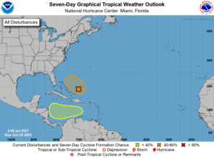 Tammy is no more but the tropical Atlantic still has some tricks in store. The area of low pressure that’s now east of the Bahamas could briefly become our next depression or tropical storm. (The next name is Vince.) But unfavorable upper level winds and drier air will start to weaken it by Tuesday, and a front is forecast to push it to the northeast. Computer models are in agreement on this scenario, but we’ll watch it, just in case. To our south, another area of low pressure is likely to form later this week and then move westward. This feature currently has a low chance of becoming a depression as it approaches Central America.
Disclaimer
Artificial Intelligence Disclosure & Legal Disclaimer
AI Content Policy.
To provide our readers with timely and comprehensive coverage, South Florida Reporter uses artificial intelligence (AI) to assist in producing certain articles and visual content.
Articles: AI may be used to assist in research, structural drafting, or data analysis. All AI-assisted text is reviewed and edited by our team to ensure accuracy and adherence to our editorial standards.
Images: Any imagery generated or significantly altered by AI is clearly marked with a disclaimer or watermark to distinguish it from traditional photography or editorial illustrations.
General Disclaimer
The information contained in South Florida Reporter is for general information purposes only.
South Florida Reporter assumes no responsibility for errors or omissions in the contents of the Service. In no event shall South Florida Reporter be liable for any special, direct, indirect, consequential, or incidental damages or any damages whatsoever, whether in an action of contract, negligence or other tort, arising out of or in connection with the use of the Service or the contents of the Service.
The Company reserves the right to make additions, deletions, or modifications to the contents of the Service at any time without prior notice. The Company does not warrant that the Service is free of viruses or other harmful components.


")


