

Sunday features plenty of hot sun in the morning on the mainland, but showers and storms will move in during the afternoon and wind down in the evening. Look for lots of sun in the Keys. Highs on Sunday will be mostly in the low 90s, with a few suburban locations reaching the mid 90s — but it will feel about 10 degrees hotter everywhere, so stay hydrated and out of the sun.
Monday will bring lots of hot sun with afternoon showers and storms developing in the afternoon on the mainland. Monday’s highs will be mostly in the low 90s.
Tuesday will feature a mix of sun, showers, and storms on the mainland. Look for plenty of clouds and periods of showers in the Keys. Tuesday’s highs will be in the low 90s.
Wednesday will see hot sun and clouds alternating with showers and storms on the mainland. Clouds and showers will linger in the Keys. Wednesday’s highs will be mostly in the mid-90s in the East Coast metro area and in the low 90s along the Gulf coast and in the Keys.

Thursday’s forecast calls for a mix of hot sun, showers, and storms on the mainland and mostly sunny skies in the Keys. Highs on Thursday will be mostly in the mid-90s on the mainland and the low 90s in the Keys.
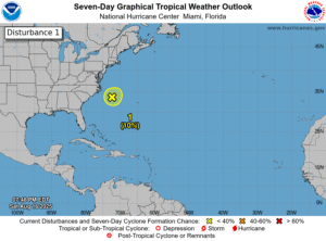 Elsewhere, a weak area of low pressure off the North Carolina coast has a low chance of becoming a depression before Monday, when conditions are expected to be unfavorable for development. And computer models indicate that an area of low pressure could form in the central Atlantic in a few days. This feature has a low chance of becoming a depression during the next week as it moves generally westward — so we’ll keep an eye on it.
Disclaimer
The information contained in South Florida Reporter is for general information purposes only.
The South Florida Reporter assumes no responsibility for errors or omissions in the contents of the Service.
In no event shall the South Florida Reporter be liable for any special, direct, indirect, consequential, or incidental damages or any damages whatsoever, whether in an action of contract, negligence or other tort, arising out of or in connection with the use of the Service or the contents of the Service. The Company reserves the right to make additions, deletions, or modifications to the contents of the Service at any time without prior notice.
The Company does not warrant that the Service is free of viruses or other harmful components


