

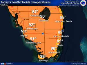
 Friday features an early mix of sun and clouds, but plenty of showers and storms will develop, especially in the morning in the east coast metro area and in the afternoon along the Gulf coast. The east coast metro area will see a brisk and gusty breeze. A moderate risk of dangerous rip currents remains at the Atlantic beaches. Highs on Friday will be near 90 degrees right at the Atlantic coast and in the low 90s elsewhere in South Florida.
LIVE RADAR 24/7 (Click Here Then Press Play)
Saturday will bring a mix of sun and clouds with mostly afternoon showers and storms. Breezy conditions in the east coast metro area will lead to a high risk of dangerous rip currents through the weekend. Saturday’s highs will be near 90 degrees in the east coast metro area and in the low 90s along the Gulf coast.
Sunday will feature a mix of sun and clouds in the morning and periods of showers and storms on a brisk ocean breeze in the afternoon. Sunday’s highs will be in the low 90s.

Monday will see good sun and a few clouds in the morning, with some showers and storms developing in the afternoon. Monday‘s highs will be in the low 90s.
Tuesday’s forecast calls for a mix of sun and clouds alternating with periods of showers and storms. Highs on Tuesday will be in the low 90s.
It’s quiet in the tropics right now, but we’ll soon enter what’s typically the most active part of the hurricane season. So, as usual in early August, both NOAA and Colorado State University (CSU) are updating their seasonal predictions.
NOAA’s revised forecast now calls for 14 to 20 named storms and 6 to 10 hurricanes, of which 3 to 5 would be major hurricanes (category 3 and above). That’s a slight decrease from the May forecast but still an above-average hurricane season.
CSU’s revised hurricane predictions call for a total of 18 named storms, 8 hurricanes, and 4 major hurricanes. That’s a slight decrease from CSU’s April numbers. CSU researchers note that sea surface temperatures in the subtropical Atlantic are a bit cooler than normal, which can lead to increased wind shear (which inhibits tropical development). CSU will also issue forecasts every two weeks during the height of the hurricane season.
We’ve already seen three tropical storms in 2022 (Alex, Bonnie, and Colin), and they’re included in the new seasonal numbers for both NOAA and CSU.
Of course, no seasonal forecast can tell you where those tropical systems will hit — but Florida is definitely in “Hurricane Alley.” The bottom line for South Florida: update your personal hurricane plan and check your supplies now. Being ready for a hurricane should be a priority for all of us.
Disclaimer
Artificial Intelligence Disclosure & Legal Disclaimer
AI Content Policy.
To provide our readers with timely and comprehensive coverage, South Florida Reporter uses artificial intelligence (AI) to assist in producing certain articles and visual content.
Articles: AI may be used to assist in research, structural drafting, or data analysis. All AI-assisted text is reviewed and edited by our team to ensure accuracy and adherence to our editorial standards.
Images: Any imagery generated or significantly altered by AI is clearly marked with a disclaimer or watermark to distinguish it from traditional photography or editorial illustrations.
General Disclaimer
The information contained in South Florida Reporter is for general information purposes only.
South Florida Reporter assumes no responsibility for errors or omissions in the contents of the Service. In no event shall South Florida Reporter be liable for any special, direct, indirect, consequential, or incidental damages or any damages whatsoever, whether in an action of contract, negligence or other tort, arising out of or in connection with the use of the Service or the contents of the Service.
The Company reserves the right to make additions, deletions, or modifications to the contents of the Service at any time without prior notice. The Company does not warrant that the Service is free of viruses or other harmful components.


")


