The relentless winter of 2026 is tightening its grip on the Eastern United States. While much of the nation has already faced record-breaking cold, AccuWeather meteorologists warn that the most dangerous stretch for the Mid-Atlantic and Northeast is unfolding now, with a dual threat of quick-hitting snow and a “brutal” Arctic front.
| Region | Peak Impact Day | Primary Hazard |
| Mid-Atlantic | Wednesday Night | Icy Roads / Light Snow |
| Great Lakes | Friday | Snow Squalls / 40 mph Winds |
| Northeast | Saturday | -20° RealFeel / 55 mph Winds |
Mid-Atlantic: A “Stripe of Snow” and Refreezing Risks
A new storm system moving through the Appalachians is forecast to bring a “quick-hitting stripe of snow” to the Mid-Atlantic through Wednesday night. While snowfall totals are expected to be lighter than the historic “bomb cyclone” seen earlier this month, the timing remains critical for commuters.
- Snowfall Totals: A coating to a few inches are expected, particularly across Virginia and North Carolina.
- The Southward Shift: Areas like Nashville and Raleigh may see a brief “warmup” into the 50s with rain, but this relief is short-lived.
- Operational Impacts: Behind the storm, temperatures will plummet back into the teens and 20s at night, creating a high risk of refreezing on untreated surfaces.
Northeast: Snow Squalls and Dangerous Cold
By Friday, an intense Arctic front will sweep from the Great Lakes into New England. This front is not just about the cold; it brings the high-risk phenomenon of snow squalls.
“Snow showers and snow squalls are going to accompany the arctic cold front as it traverses the Northeast on Friday,” warned AccuWeather Meteorologist Peyton Simmers. “These snow showers and squalls can limit visibility and lead to roads becoming snow-covered and icy quickly.”
The intensity of the incoming air mass is staggering:
- Wind Gusts: 30–40 mph in the Ohio Valley Friday, increasing to 50–55 mph in New England by Saturday.
- RealFeel® Temperatures: AccuWeather experts project values could drop to 10–30 degrees below zero in wind-prone areas.
- Infrastructure Stress: The extreme cold is expected to drive up energy demand and increase the risk of pipe bursts in residential and commercial buildings.
Long-Range Outlook: When Will It End?
For those exhausted by the single-digit lows, relief is on the horizon, though it will be a “slow and uneven” process.
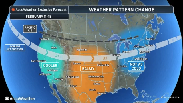
Paul Pastelok, AccuWeather Lead Long-Range Expert, notes that a shift toward less cold Pacific air is expected to begin mid-February. “The transition to warmer spring weather will be slower across the Northeast, Great Lakes, and the Pacific Northwest this year,” Pastelok stated. While daytime highs may eventually reach the 30s and 40s, the deep snow cover and frozen rivers in the Midwest will limit how quickly the region can warm up.
Source: AccuWeather
Disclaimer
Artificial Intelligence Disclosure & Legal Disclaimer
AI Content Policy.
To provide our readers with timely and comprehensive coverage, South Florida Reporter uses artificial intelligence (AI) to assist in producing certain articles and visual content.
Articles: AI may be used to assist in research, structural drafting, or data analysis. All AI-assisted text is reviewed and edited by our team to ensure accuracy and adherence to our editorial standards.
Images: Any imagery generated or significantly altered by AI is clearly marked with a disclaimer or watermark to distinguish it from traditional photography or editorial illustrations.
General Disclaimer
The information contained in South Florida Reporter is for general information purposes only.
South Florida Reporter assumes no responsibility for errors or omissions in the contents of the Service. In no event shall South Florida Reporter be liable for any special, direct, indirect, consequential, or incidental damages or any damages whatsoever, whether in an action of contract, negligence or other tort, arising out of or in connection with the use of the Service or the contents of the Service.
The Company reserves the right to make additions, deletions, or modifications to the contents of the Service at any time without prior notice. The Company does not warrant that the Service is free of viruses or other harmful components.


