

The United States is currently bracing for one of the most significant and geographically expansive weather events of the decade. Meteorologists are tracking a “March Megastorm” that is expected to rapidly intensify into a bomb cyclone by Monday afternoon. This powerful weather system is not a single-threat event; it is a “triple threat” packing dangerous blizzard conditions, widespread damaging wind gusts, and the potential for a volatile tornado outbreak. As the storm sweeps across two-thirds of the country—from the Rockies and Upper Midwest to the East Coast—more than 200 million people are likely to feel its impact through power outages, major travel disruptions, and forced business or school shutdowns.
A Rapidly Intensifying Bomb Cyclone
According to the latest data, the storm is expected to undergo “bombogenesis”—a process where the central atmospheric pressure of a storm drops at least 24 millibars in 24 hours. This rapid intensification indicates a strengthening system capable of producing extreme weather across a massive corridor.
“The storm is expected to intensify rapidly enough from Sunday into Monday to likely meet bomb cyclone criteria,” AccuWeather experts noted, signaling a high-impact event that will stretch from the central U.S. into the Northeast.
The Blizzard Zone: 1–4 Feet of Snow
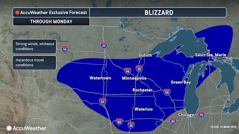 While the southern and eastern portions of the country deal with wind and rain, the Upper Midwest is facing a historic winter event. AccuWeather expert meteorologists have already reported thundersnow and intense snowfall rates of 3–4 inches per hour in parts of Wisconsin.

The blizzard zone has been expanded to include:
- Wisconsin
- Michigan
- Iowa
- Northern Illinois
- Southeastern Minnesota
In a swath stretching from Minneapolis to Michigan’s Upper Peninsula, total accumulations are forecast to reach 1–4 feet of snow. AccuWeather Meteorologist Brandon Buckingham highlighted the severity of the situation in Michigan: “Many locations across the Upper Peninsula of Michigan still have 20–50 inches of snow on the ground, prior to the arrival of the current storm. Through early week, there is the potential for an additional 1–4 feet of snow from the storm, which will further deepen the snowpack across the region.”
Buckingham warned that the sheer volume of snow could remain on the ground well into May. Meanwhile, a “flash freeze” concern looms for cities like Chicago, Detroit, and St. Louis, where rain is expected to turn to snow as temperatures plunge, turning wet roads into sheets of ice by Monday morning.
High-Risk Severe Weather and Nighttime Tornadoes
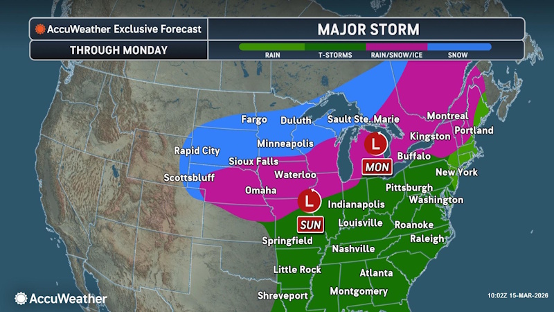 To the south and east, the primary threat shifts from snow to severe thunderstorms. A widespread outbreak is expected from Texas to southern Michigan through Sunday night. The most dangerous area extends from northern Louisiana and central Mississippi into southern Illinois and western Kentucky.
Meteorologists are particularly concerned about nighttime storms. Severe weather that occurs after dark is statistically more dangerous because residents are often asleep and unable to see approaching clouds. Experts urge residents in these areas to have multiple ways to receive warnings, such as the AccuWeather app, and to ensure storm shelters are ready for immediate use.
By Monday, this severe threat moves toward the Atlantic. A “high-risk” area has been designated from Washington, D.C., to the Carolinas. AccuWeather Chief Meteorologist Jonathan Porter warned of the volatile nature of this transition: “The severe weather setup across parts of the mid-Atlantic can be volatile Monday if several atmospheric factors conspire together, which may produce one of the most impactful and dangerous early-season severe weather events in this part of the country over the last decade.”
Damaging Winds and Infrastructure Risks
Even outside of the snow and tornado zones, the “Megastorm” will generate ferocious winds. Gusts of 40–60 mph are expected from New Mexico all the way to Maine. However, near the most intense thunderstorms, Porter explains that “widespread damaging wind gusts of 60–70 mph with an AccuWeather Local StormMax™ of 100 mph can occur.”
These hurricane-force gusts pose a severe risk to:
- Power Grids: Falling trees and branches are likely to cause widespread outages, especially in the densely populated I-95 corridor.
- Transportation: High-profile vehicles face hazardous travel conditions, and flight cancellations are expected to reach the thousands at hubs like O’Hare, Hartsfield-Jackson, and JFK.
- Vulnerable Communities: Areas in the South still recovering from a January ice storm are particularly susceptible to further tree damage and prolonged power loss.
Economic and Social Impact
This March Megastorm follows a series of incredibly costly weather events in 2026. Earlier this year, a historic winter storm in January caused between $105B–$115B in damages, followed by a $34B–$38B February blizzard. This current storm is expected to add significantly to those totals, given the potential for business disruptions during the Monday evening commute in major metros like Philadelphia, Richmond, and Baltimore.
“The storms may be poorly timed relative to the rush hour,” Porter warned. “While damaging straight-line winds are the most likely severe weather hazard, a few tornadoes, including the possibility of an especially intense tornado, cannot be ruled out.”
As the bomb cyclone continues its path, residents are urged to stay weather-aware, secure loose outdoor objects, and avoid travel in the blizzard and high-risk zones until the system passes on Tuesday.
Sources:
- AccuWeather: accuweather.com
Disclaimer
Artificial Intelligence Disclosure & Legal Disclaimer
AI Content Policy.
To provide our readers with timely and comprehensive coverage, South Florida Reporter uses artificial intelligence (AI) to assist in producing certain articles and visual content.
Articles: AI may be used to assist in research, structural drafting, or data analysis. All AI-assisted text is reviewed and edited by our team to ensure accuracy and adherence to our editorial standards.
Images: Any imagery generated or significantly altered by AI is clearly marked with a disclaimer or watermark to distinguish it from traditional photography or editorial illustrations.
General Disclaimer
The information contained in South Florida Reporter is for general information purposes only.
South Florida Reporter assumes no responsibility for errors or omissions in the contents of the Service. In no event shall South Florida Reporter be liable for any special, direct, indirect, consequential, or incidental damages or any damages whatsoever, whether in an action of contract, negligence or other tort, arising out of or in connection with the use of the Service or the contents of the Service.
The Company reserves the right to make additions, deletions, or modifications to the contents of the Service at any time without prior notice. The Company does not warrant that the Service is free of viruses or other harmful components.
")


")

. Here’s What to Know")

")

