

Sunday features lots of sun on the mainland, but look for some afternoon showers in the East Coast metro area and a few storms in the afternoon along the Gulf Coast. The keys will see a mix of sun and clouds with periods of showers and storms. A high risk of dangerous rip currents continues at the Atlantic beaches. Minor flooding near high tides is possible along the Atlantic coast. Highs on Sunday will be in the mid-80s in the East Coast metro area and the Keys and in the upper 80s along the Gulf Coast.
Monday will bring mostly sunny skies and periods of showers and storms to the east coast metro area. The Gulf coast will be sunny, while the Keys will see a nice mix of showers and storms. Monday’s highs will be mostly in the upper 80s on the mainland and the mid 80s in the Keys.
Tuesday will feature lots of sun and a few afternoon showers and storms in spots in the east coast metro area. The Gulf coast will see another sunny day, and the Keys will be mostly sunny with maybe a stray shower. Tuesday’s highs will be in the upper 80s on the mainland and the mid 80s in the Keys.
Wednesday will be sunny around South Florida, but we can’t rule out a stray shower or storm in the east coast metro area. Wednesday’s highs will be in the upper 80s on the mainland and the mid 80s in the Keys.

Thursday’s forecast calls for plenty of sun and a few clouds. Some locations in the east coast metro area could also see a stray shower or storm in the afternoon. Highs on Thursday will be mostly in the mid 80s.
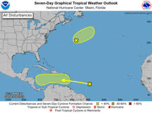 In the tropics, we’re watching a wave in the central Atlantic that’s approaching the Windward Islands. This wave currently has a low chance of development once it reaches the Caribbean in a day or so — and we’ll continue to keep an eye on it. Elsewhere, a low far off the U.S. northeast coast has a low chance of becoming a subtropical depression before moving into much colder waters in a day or two.
Disclaimer
Artificial Intelligence Disclosure & Legal Disclaimer
AI Content Policy.
To provide our readers with timely and comprehensive coverage, South Florida Reporter uses artificial intelligence (AI) to assist in producing certain articles and visual content.
Articles: AI may be used to assist in research, structural drafting, or data analysis. All AI-assisted text is reviewed and edited by our team to ensure accuracy and adherence to our editorial standards.
Images: Any imagery generated or significantly altered by AI is clearly marked with a disclaimer or watermark to distinguish it from traditional photography or editorial illustrations.
General Disclaimer
The information contained in South Florida Reporter is for general information purposes only.
South Florida Reporter assumes no responsibility for errors or omissions in the contents of the Service. In no event shall South Florida Reporter be liable for any special, direct, indirect, consequential, or incidental damages or any damages whatsoever, whether in an action of contract, negligence or other tort, arising out of or in connection with the use of the Service or the contents of the Service.
The Company reserves the right to make additions, deletions, or modifications to the contents of the Service at any time without prior notice. The Company does not warrant that the Service is free of viruses or other harmful components.


")