

Wednesday features lots of sun and a cloud or two at times around South Florida. Highs on Wednesday will be mostly in the upper 80s on the mainland and in the mid-80s in the Keys.
Thursday will bring breezy conditions, plenty of sun, and a few clouds to the east coast metro area. The Gulf coast will be sunny with a brisk breeze, and the Keys will see lots of sun. Look for an increasing risk of dangerous rip currents at the Atlantic beaches. Thursday’s highs will be mostly in the mid 80s in the east coast metro area and the Keys and in the upper 80s along the Gulf coast.
Friday will be breezy and sunny around South Florida. Friday’s highs will be mostly in the mid-80s along the East Coast metro area and the Keys, and in the upper 80s along the Gulf Coast.
Saturday will feature breezy conditions and lots of sun on the mainland. The East Coast metro area could also see a shower or two in the afternoon. Look for plenty of clouds and a few showers in the Keys. Saturday’s highs will be in the mid-80s in the East Coast metro area and the Keys, while the Gulf Coast will reach the upper 80s.

Sunday’s forecast calls for breezy conditions, mostly sunny skies, and a few East Coast metro area showers. The Gulf coast will see lots of sun, but clouds and showers will linger in the Keys. Highs on Sunday will be in the mid-80s in the East Coast metro area and the Keys and in the upper 80s along the Gulf Coast.

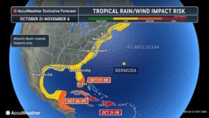 Timing is everything with late-season storms, and in Melissa’s case, we’ll watch to see if it will be moving quickly enough to be caught up by a front late in the weekend. Computer models don’t agree on whether or not that will happen. So we’ll need to keep a close eye on Melissa during the coming days.
Disclaimer
Artificial Intelligence Disclosure & Legal Disclaimer
AI Content Policy.
To provide our readers with timely and comprehensive coverage, South Florida Reporter uses artificial intelligence (AI) to assist in producing certain articles and visual content.
Articles: AI may be used to assist in research, structural drafting, or data analysis. All AI-assisted text is reviewed and edited by our team to ensure accuracy and adherence to our editorial standards.
Images: Any imagery generated or significantly altered by AI is clearly marked with a disclaimer or watermark to distinguish it from traditional photography or editorial illustrations.
General Disclaimer
The information contained in South Florida Reporter is for general information purposes only.
South Florida Reporter assumes no responsibility for errors or omissions in the contents of the Service. In no event shall South Florida Reporter be liable for any special, direct, indirect, consequential, or incidental damages or any damages whatsoever, whether in an action of contract, negligence or other tort, arising out of or in connection with the use of the Service or the contents of the Service.
The Company reserves the right to make additions, deletions, or modifications to the contents of the Service at any time without prior notice. The Company does not warrant that the Service is free of viruses or other harmful components.


")


")
