

Thursday features some sun, more clouds, and plenty of showers in the afternoon. Some of those showers will hang around into the evening in the East Coast metro area. Expect an elevated risk of dangerous rip currents along the Palm Beach County coast. Highs on Thursday will be in the low 90s — but it will feel at least 10 degrees hotter, so stay hydrated and out of the sun.
Friday will bring morning sun and showers to the East Coast metro area, but storms will develop in the afternoon and evening. The Gulf Coast will be mostly sunny in the morning with afternoon storms that will linger into the evening. Friday’s highs will be in the low 90s.
Saturday will feature some morning storms, followed by plenty of afternoon and evening showers. Saturday’s highs will be in the low 90s.
Sunday will see a mix of sun, clouds, showers, and some storms. Look for those showers and storms to begin in the mid-morning along the East Coast and in the mid-afternoon along the Gulf Coast. Sunday’s highs will be in the low 90s..

Monday’s forecast calls for a mix of sun, clouds, showers, and storms on the mainland, while the Keys will see clouds and showers. Highs on Monday will be near 90 degrees in the East Coast metro area and the Keys and in the low 90s along the Gulf Coast.
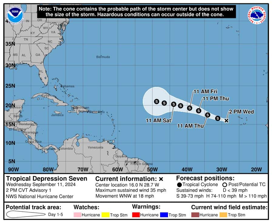 The trough of low pressure in the eastern Atlantic becameTropical Depression # 7 on Wednesday, and it is forecast to reach tropical storm status at any time. (The next name on the list is Gordon.) Late Wednesday afternoon, TD # 7 had maximum sustained winds of 35 miles per hour and was moving west-northwest at 18 miles per hour. While computer models show an eventual turn to the north, we’ll keep an eye on it until that turn actually happens.
 Elsewhere, the area of low pressure in the central Atlantic has a low chance of becoming a depression as it enters an area of hostile conditions. Another low that’s a few hundred miles east of the Lesser Antilles is disorganized and has a low chance of developing as it encounters dry air. And a non-tropical low is expected to form off the southeast U.S. coast in a couple of days. This system could acquire some tropical or subtropical characteristics during the next week, but the chance of development still remains low.
Disclaimer
Artificial Intelligence Disclosure & Legal Disclaimer
AI Content Policy.
To provide our readers with timely and comprehensive coverage, South Florida Reporter uses artificial intelligence (AI) to assist in producing certain articles and visual content.
Articles: AI may be used to assist in research, structural drafting, or data analysis. All AI-assisted text is reviewed and edited by our team to ensure accuracy and adherence to our editorial standards.
Images: Any imagery generated or significantly altered by AI is clearly marked with a disclaimer or watermark to distinguish it from traditional photography or editorial illustrations.
General Disclaimer
The information contained in South Florida Reporter is for general information purposes only.
South Florida Reporter assumes no responsibility for errors or omissions in the contents of the Service. In no event shall South Florida Reporter be liable for any special, direct, indirect, consequential, or incidental damages or any damages whatsoever, whether in an action of contract, negligence or other tort, arising out of or in connection with the use of the Service or the contents of the Service.
The Company reserves the right to make additions, deletions, or modifications to the contents of the Service at any time without prior notice. The Company does not warrant that the Service is free of viruses or other harmful components.


")


")

")