

Saturday features a mix of sun and clouds, with periods of showers and storms in the East Coast metro area and the Keys. The Gulf Coast will see more clouds than sun and lots of showers. Expect an elevated risk of dangerous rip currents at the Atlantic beaches. Highs on Saturday will be in the low 90s in the East Coast metro area and the Keys and near 90 degrees along the Gulf Coast.
Sunday will bring lots of morning sun and a few afternoon showers and storms to the East Coast metro area. The Gulf Coast will be mostly sunny with a few showers and storms. Sunday’s highs will be mostly in the low 90s.
Monday will feature good sun and a few clouds in the morning, with a few showers and maybe a storm in the afternoon. Monday’s highs will be in the low 90s on the mainland and near 90 degrees in the Keys.
Tuesday will be sunny until some showers and storms develop in the afternoon and early evening. Tuesday’s highs will be near 90 degrees on the mainland and in the upper 80s in the Keys.

Wednesday’s forecast calls for mostly sunny skies alternating with showers and storms. Highs on Wednesday will be near 90 degrees on the mainland and in the upper 80s in the Keys.
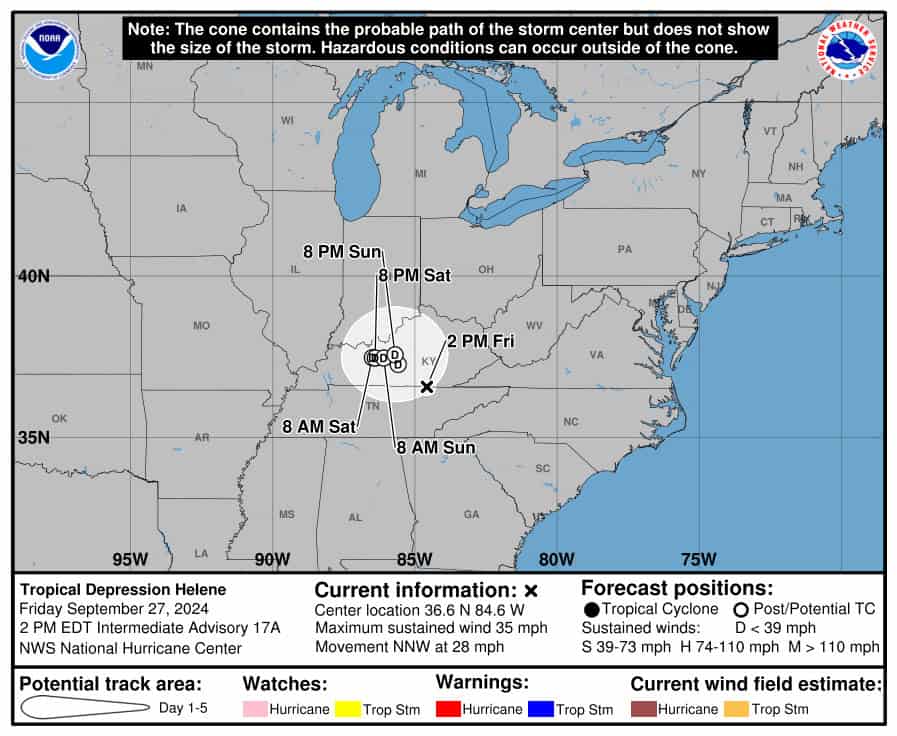 Helene is weakening and losing its tropical characteristics, but it has not lost its ability to cause devastation. It is forecast to linger over Kentucky and Tennessee on Saturday and will continue to drop flooding rains over much of the southeastern U.S.
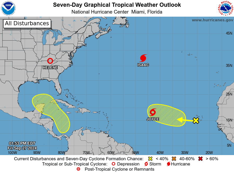 Elsewhere, Hurricane Isaac is moving rapidly in the northern Atlantic, far from land. Isaac will weaken on Sunday and become an extra-tropical cyclone early next week. The area of low pressure in the central Atlantic is now Tropical Storm Joyce. Joyce is forecast to turn northward and weaken in the middle of the Atlantic early next week. In the eastern Atlantic, an area of low pressure could form in a few days. Computer models suggest this feature will follow in Joyce’s path as it makes its way northwestward.
Finally, computer models indicate a low could form in the western Caribbean by the middle of next week. This feature is likely to end up in the Gulf of Mexico — and we’ll keep a close eye on it.
Disclaimer
Artificial Intelligence Disclosure & Legal Disclaimer
AI Content Policy.
To provide our readers with timely and comprehensive coverage, South Florida Reporter uses artificial intelligence (AI) to assist in producing certain articles and visual content.
Articles: AI may be used to assist in research, structural drafting, or data analysis. All AI-assisted text is reviewed and edited by our team to ensure accuracy and adherence to our editorial standards.
Images: Any imagery generated or significantly altered by AI is clearly marked with a disclaimer or watermark to distinguish it from traditional photography or editorial illustrations.
General Disclaimer
The information contained in South Florida Reporter is for general information purposes only.
South Florida Reporter assumes no responsibility for errors or omissions in the contents of the Service. In no event shall South Florida Reporter be liable for any special, direct, indirect, consequential, or incidental damages or any damages whatsoever, whether in an action of contract, negligence or other tort, arising out of or in connection with the use of the Service or the contents of the Service.
The Company reserves the right to make additions, deletions, or modifications to the contents of the Service at any time without prior notice. The Company does not warrant that the Service is free of viruses or other harmful components.


")


")
