

Sunday features hot sun and periods of showers in the morning on the mainland, but look for storms in the afternoon and early evening. The Keys will be mostly sunny with maybe a stray shower. A high risk of dangerous rip currents remains along the Palm Beach County coast and an elevated rip current risk at the Broward and Miami-Dade beaches. Highs on Sunday will be mostly in the low 90s — but it will feel like the triple digits, so stay hydrated and out of the sun.
Monday will bring a mix of sun, clouds, and periods of showers and storms to the mainland, while the Keys will see lots of sun. Monday’s highs will be mostly in the low 90s, but a few suburban locations could reach the mid-90s.
Tuesday will feature mostly sunny skies with afternoon showers and storms in the East Coast metro area. The Gulf Coast will see a mix of sun, showers, and storms, while the Keys will see good sun and a few clouds. Tuesday’s highs will be mostly in the humid low 90s.
Wednesday will see mostly sunny skies alternating with showers and storms on the mainland. Look for plenty of sun and a few clouds in the Keys. Wednesday’s highs will be in the low-90s.

Thursday’s forecast calls for hot sun and plenty of showers and storms on the mainland, while the Keys will see more clouds than sun and periods of showers. Highs on Thursday will be in the low 90s on the mainland and near 90 degrees in the Keys.
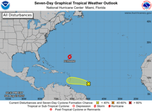
In the tropics, the area of disturbed weather well north of the Leeward Islands is now Tropical Storm Fernand. Late Saturday afternoon, TS Fernand was about 405 miles south-southeast of Bermuda and had maximum sustained winds of 40 miles per hour. Fernand was moving north at 15 miles per hour at that time and is forecast to pass well east of Bermuda and remain in the open ocean.
Well to the south, a wave in the central Atlantic currently has a low chance of developing, but it will bring heavy rain and gusty winds to the Windward Islands on Sunday and Monday. After that, this feature will encounter unfavorable conditions in the eastern Caribbean starting on Tuesday.
Disclaimer
Artificial Intelligence Disclosure & Legal Disclaimer
AI Content Policy.
To provide our readers with timely and comprehensive coverage, South Florida Reporter uses artificial intelligence (AI) to assist in producing certain articles and visual content.
Articles: AI may be used to assist in research, structural drafting, or data analysis. All AI-assisted text is reviewed and edited by our team to ensure accuracy and adherence to our editorial standards.
Images: Any imagery generated or significantly altered by AI is clearly marked with a disclaimer or watermark to distinguish it from traditional photography or editorial illustrations.
General Disclaimer
The information contained in South Florida Reporter is for general information purposes only.
South Florida Reporter assumes no responsibility for errors or omissions in the contents of the Service. In no event shall South Florida Reporter be liable for any special, direct, indirect, consequential, or incidental damages or any damages whatsoever, whether in an action of contract, negligence or other tort, arising out of or in connection with the use of the Service or the contents of the Service.
The Company reserves the right to make additions, deletions, or modifications to the contents of the Service at any time without prior notice. The Company does not warrant that the Service is free of viruses or other harmful components.

")

. Here’s What to Know")

")


