

Monday features hot sun with a few clouds, showers, and storms in the East Coast metro area. The Gulf Coast will be sunny in the morning, but plenty of storms will develop in the afternoon. Look for some sun, more clouds, and some showers in the Keys. Highs on Monday will be mostly in the low 90s, with a few inland locations reaching the mid-90s. But it will feel about 10 degrees hotter everywhere, so stay hydrated and out of the sun.
Tuesday will bring mostly sunny skies and mainly afternoon and early evening showers and storms to the East Coast metro area. The Gulf Coast will see lots of sun in the morning, but storms will return in the afternoon and linger into the evening. Tuesday’s highs will be in the low 90s;
Wednesday will repeat the pattern: a mix of sun and clouds with some showers and storms in the East Coast metro area and a sunny morning followed by storms in the afternoon and evening along the Gulf Coast. Wednesday’s highs will be in the low 90s.

Thursday will feature lots of sun in the morning and some showers and storms from the mid-afternoon into the early evening. Thursday’s highs will be mostly in the low 90s, but a few inland locations will top out in the mid-90s.
Friday’s forecast calls for a mix of hot sun, showers, and storms. Highs on Friday will be in the low 90s right at the coasts and in the Keys, while the rest of South Florida will reach the mid-90s.
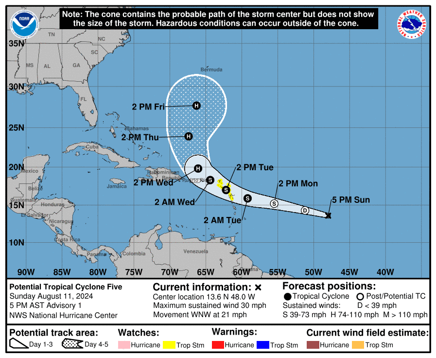 In the tropics, the wave in the central Atlantic became Potential Tropical Cyclone # 5 late Sunday afternoon. At that time, it was located about 950 miles east-southeast of Antigua. Maximum sustained winds were 30 miles per hour, and Potential TD # 5 was moving west-northwest at a rapid 21 miles per hour. It’s forecast to be a tropical storm before reaching the Lesser Antilles on Tuesday. (The next name on the list is Ernesto.) There are tropical storm watches for Guadeloupe, St. Kitts, Nevis, Montserrat, Antigua, Barbuda, Anguilla, Sint Maarten, St. Martin and Saba. Puerto Rico and the Virgin Islands are likely to see impacts from what’s now Potential TD # 5 later this week, and then a northward turn well east of the Bahamas is in the forecast. We’ll keep an eye on it.
Disclaimer
Artificial Intelligence Disclosure & Legal Disclaimer
AI Content Policy.
To provide our readers with timely and comprehensive coverage, South Florida Reporter uses artificial intelligence (AI) to assist in producing certain articles and visual content.
Articles: AI may be used to assist in research, structural drafting, or data analysis. All AI-assisted text is reviewed and edited by our team to ensure accuracy and adherence to our editorial standards.
Images: Any imagery generated or significantly altered by AI is clearly marked with a disclaimer or watermark to distinguish it from traditional photography or editorial illustrations.
General Disclaimer
The information contained in South Florida Reporter is for general information purposes only.
South Florida Reporter assumes no responsibility for errors or omissions in the contents of the Service. In no event shall South Florida Reporter be liable for any special, direct, indirect, consequential, or incidental damages or any damages whatsoever, whether in an action of contract, negligence or other tort, arising out of or in connection with the use of the Service or the contents of the Service.
The Company reserves the right to make additions, deletions, or modifications to the contents of the Service at any time without prior notice. The Company does not warrant that the Service is free of viruses or other harmful components.


")


")
