

Saturday features a mix of sun, clouds, and mainly afternoon and early evening showers and storms on the mainland. The Keys will be mostly sunny with a few showers in spots. A high risk of dangerous rip currents remains at the Atlantic beaches through at least Saturday afternoon. Highs on Saturday will be mostly in the low-90s, with a few suburban and inland locations reaching the mid-90s — but it will feel much hotter, so stay hydrated and out of the sun.
Sunday will bring mostly sunny skies and some afternoon showers and storms to the mainland, while the Keys will see a mix of sun and clouds. Sunday‘s highs will be mostly in the sticky low-90s.
Monday will feature a mix of hot sun, showers, and storms on the mainland and mostly sunny skies in the Keys. Monday‘s highs will be mostly in the mid-90s in the East Coast metro area and in the low-90s along the Gulf Coast and in the Keys.
Tuesday will be another day of hot sun with periods of showers and storms on the mainland. Look for plenty of clouds and some showers in the Keys. Tuesday‘s highs will be mostly in the low-90s, with a few suburban locations reaching the mid-90s.
Wednesday‘s forecast calls for a mix of hot sun, showers, and storms — it’s August in South Florida, after all. Highs on Wednesday will be mostly in the low 90s.
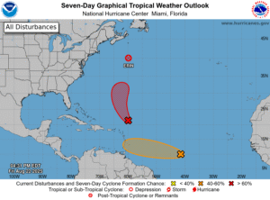 Erin has transitioned to a post-tropical system and is racing away from the US East Coast. But the waves, rough surf, and dangerous rip currents from the system continue to affect the Atlantic seaboard.
Late Friday afternoon, Erin was about 375 south-southeast of Halifax, Nova Scotia. Maximum sustained winds were 90 miles per hour, and Erin was zooming east-northeast at 33 miles per hour. There were no watches or warnings at that time.
Elsewhere in the tropics, the wave northeast of the Leeward Islands has a high chance of becoming a depression this weekend. This feature poses no threat to the US coast but could affect Bermuda next week. And the wave that’s now in the central Atlantic has a medium chance of developing before it reaches an area with unfavorable conditions. If it holds together after that, we’ll need to keep an eye on it as it reaches the Lesser Antilles early next week.
Disclaimer
Artificial Intelligence Disclosure & Legal Disclaimer
AI Content Policy.
To provide our readers with timely and comprehensive coverage, South Florida Reporter uses artificial intelligence (AI) to assist in producing certain articles and visual content.
Articles: AI may be used to assist in research, structural drafting, or data analysis. All AI-assisted text is reviewed and edited by our team to ensure accuracy and adherence to our editorial standards.
Images: Any imagery generated or significantly altered by AI is clearly marked with a disclaimer or watermark to distinguish it from traditional photography or editorial illustrations.
General Disclaimer
The information contained in South Florida Reporter is for general information purposes only.
South Florida Reporter assumes no responsibility for errors or omissions in the contents of the Service. In no event shall South Florida Reporter be liable for any special, direct, indirect, consequential, or incidental damages or any damages whatsoever, whether in an action of contract, negligence or other tort, arising out of or in connection with the use of the Service or the contents of the Service.
The Company reserves the right to make additions, deletions, or modifications to the contents of the Service at any time without prior notice. The Company does not warrant that the Service is free of viruses or other harmful components.


