

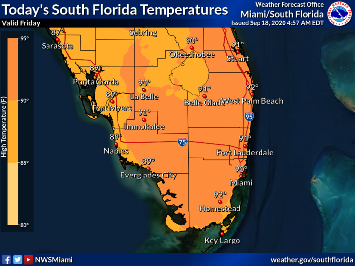
 Friday features plenty of hot sun and some showers (with a few storms) from late morning into the afternoon. Minor coastal flooding is possible in Miami-Dade and Broward through Sunday. A high risk of dangerous rip currents remains along the Palm Beach County coast, and there’s a moderate rip current risk at the Miami-Dade and Broward beaches. Highs on Friday will be in the low 90s in the east coast metro area and the upper 80s along the Gulf coast.
LIVE RADAR 24/7 (Click Here Then Press Play)
Saturday will start with mostly sunny skies, and showers and a few storms will develop in the afternoon. Saturday’s highs will be in the low 90s.
Sunday will bring good sun alternating with periods of showers and storms. Sunday’s highs will be near 90 degrees.

Monday will feature mostly sunny skies in the morning, a building ocean breeze, and widespread showers and storms in the afternoon. Monday’s highs will be in the upper 80s.
Tuesday’s forecast includes good sun alternating with periods of showers and storms. Highs on Tuesday will be in the upper 80s.
 In the tropics, Teddy has become a major hurricane. At 5 am, Teddy was located 21.6 North, 55.4 West, about 935 miles southeast of Bermuda. Maximum sustained winds were 130 miles per hour. Teddy was moving northwest at 12 miles per hour. Impacts of Teddy are forecast to be felt on Bermuda on Sunday.
 Tropical Depression # 22 has formed from the low in the southwestern Gulf of Mexico, and it is likely to be a tropical storm by late Friday (and exhaust the 2020 list of Atlantic hurricane names). At 5 am, TD # 22 was located near 22.9 North, 94.1 West. and was moving north-northeast at 6 miles per hour. Maximum sustained winds were 35 miles per hour. This system will move slowly and linger near the Texas coast this weekend into early next week.
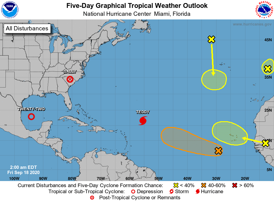 Elsewhere, the remnants of Sally are dropping heavy rain in the Carolinas. The non-tropical low in the northeastern Atlantic has a low chance of becoming a subtropical depression before reaching Portugal. The wave southwest of the Cape Verde Islands has a medium chance of developing into a depression in the next few days. Yet another disturbance over Africa is forecast to reach the eastern Atlantic in a few days and have a low chance of development. And finally, Post-Tropical Cyclone Paulette is forecast to move southward and stall out over warmer waters — and have a low chance of redeveloping tropical characteristics.
Disclaimer
The information contained in South Florida Reporter is for general information purposes only.
The South Florida Reporter assumes no responsibility for errors or omissions in the contents of the Service.
In no event shall the South Florida Reporter be liable for any special, direct, indirect, consequential, or incidental damages or any damages whatsoever, whether in an action of contract, negligence or other tort, arising out of or in connection with the use of the Service or the contents of the Service. The Company reserves the right to make additions, deletions, or modifications to the contents of the Service at any time without prior notice.
The Company does not warrant that the Service is free of viruses or other harmful components


")

