

Thursday features hot sun in the morning, followed by periods of showers and storms in the afternoon and early evening on the mainland. The Keys will see mostly sunny skies with maybe a shower. Highs on Thursday will be mostly in the low 90s — but it will feel about 10 degrees hotter, so stay hydrated and out of the sun.
Friday will bring lots of hot sun and some mid to late afternoon showers and storms to the mainland, while the Keys will see a mix of sun and clouds. Friday’s highs will be in the low 90s in the east coast metro area and the Keys and in the mid 90s along the Gulf coast.
Saturday will feature a mix of sun, showers, and a few storms in the east coast metro area. The Gulf coast will see a sunny morning and some showers and storms in spots in the afternoon. Look for good sun and a few clouds in the Keys. Saturday’s highs will be mostly in the low 90s, with a few inland locations on the mainland reaching the mid 90s.
Sunday will see a mix of sun and a few showers and storms in the morning on the mainland, but more showers and storms will develop in the afternoon and early evening. The Keys will see more clouds than sun and periods of showers. Sunday’s highs will be mostly in the low 90s on the mainland, but a few suburban locations will top out in the mid 90s. Highs in the Keys will be near 90 degrees.

Monday’s forecast calls for a typical August mix of sun, clouds, showers, and some storms on the mainland. Look for lots of sun in the Keys. Highs on Monday will be mostly in the low 90s.
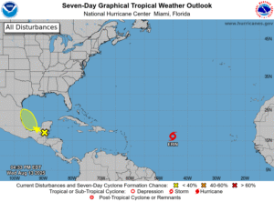 In the tropics, Tropical Storm Erin continues to move westward into an area that will be favorable for development. Erin was located about 1400 miles east of the northern Leeward Islands late Wednesday afternoon, and it was moving west at 17 miles per hour. Maximum sustained winds were 50 miles per hour at that time. Erin is forecast to reach hurricane strength on Friday and intensify into a major hurricane late in the weekend. Its exact track will determine what impacts, if any, Erin will have on Puerto Rico and the Virgin Islands. Computer models have come more into agreement on a turn to the northwest early next week. The question will be how far east of the Bahamas that turn will be. We’ll continue to watch Erin closely.
Elsewhere, a wave that was in the northwestern Caribbean is crossing the Yucatan. This feature has a low chance of developing into a depression once it reaches the Bay of Campeche and moves generally northwest just off the Mexican coast.
Disclaimer
Artificial Intelligence Disclosure & Legal Disclaimer
AI Content Policy.
To provide our readers with timely and comprehensive coverage, South Florida Reporter uses artificial intelligence (AI) to assist in producing certain articles and visual content.
Articles: AI may be used to assist in research, structural drafting, or data analysis. All AI-assisted text is reviewed and edited by our team to ensure accuracy and adherence to our editorial standards.
Images: Any imagery generated or significantly altered by AI is clearly marked with a disclaimer or watermark to distinguish it from traditional photography or editorial illustrations.
General Disclaimer
The information contained in South Florida Reporter is for general information purposes only.
South Florida Reporter assumes no responsibility for errors or omissions in the contents of the Service. In no event shall South Florida Reporter be liable for any special, direct, indirect, consequential, or incidental damages or any damages whatsoever, whether in an action of contract, negligence or other tort, arising out of or in connection with the use of the Service or the contents of the Service.
The Company reserves the right to make additions, deletions, or modifications to the contents of the Service at any time without prior notice. The Company does not warrant that the Service is free of viruses or other harmful components.

")
")

")


")
")