

Saturday features hot sun, a few morning showers, and periods of storms in the afternoon in the East Coast metro area. The Gulf Coast will be mostly sunny in the morning, but storms will develop during the afternoon. The Keys will see a mix of sun, clouds, and a few showers in spots. Highs on Saturday will be mostly in the low 90s, with a few inland locations reaching the mid-90s. But it will feel about 10 degrees hotter around South Florida, so stay hydrated and out of the sun.
Sunday will bring a mix of sun, clouds, and mainly afternoon showers and storms. Sunday’s highs will be mostly in the mid-90s in the East Coast metro area and in the low 90s along the Gulf Coast and in the Keys.
Monday will feature sun and a few storms in the morning, followed by afternoon showers that will linger into the evening. Monday’s highs will be in the low 90s.
Tuesday will see sun, clouds, and showers in the East Coast metro area and the Keys. The Gulf Coast will see morning storms and afternoon showers. Tuesday’s highs will be in the low 90s on the mainland and near 90 degrees in the Keys.

Wednesday’s forecast calls for a mix of sun, showers, and storms. Highs on Wednesday will be in the low 90s.
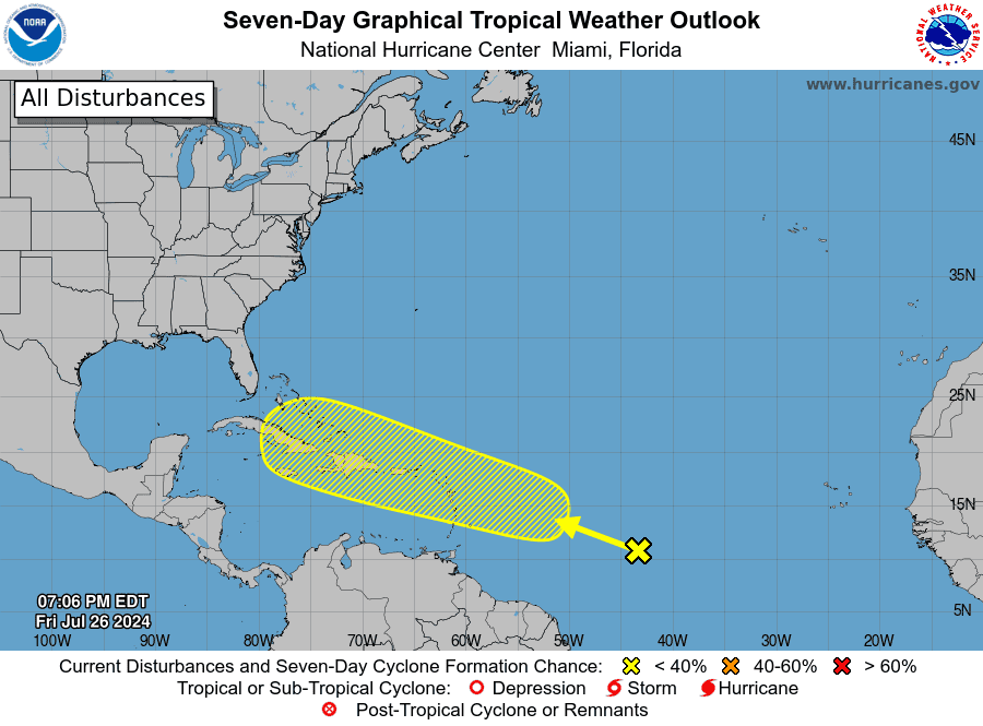 In the tropics, an area of disturbed weather in the central Atlantic has a low chance of developing after it interacts with a tropical wave in a few days. While this feature will move west-northwestward through the Antilles, it still is likely to be affected by Saharan dust. We’ll keep an eye on the situation.
Disclaimer
Artificial Intelligence Disclosure & Legal Disclaimer
AI Content Policy.
To provide our readers with timely and comprehensive coverage, South Florida Reporter uses artificial intelligence (AI) to assist in producing certain articles and visual content.
Articles: AI may be used to assist in research, structural drafting, or data analysis. All AI-assisted text is reviewed and edited by our team to ensure accuracy and adherence to our editorial standards.
Images: Any imagery generated or significantly altered by AI is clearly marked with a disclaimer or watermark to distinguish it from traditional photography or editorial illustrations.
General Disclaimer
The information contained in South Florida Reporter is for general information purposes only.
South Florida Reporter assumes no responsibility for errors or omissions in the contents of the Service. In no event shall South Florida Reporter be liable for any special, direct, indirect, consequential, or incidental damages or any damages whatsoever, whether in an action of contract, negligence or other tort, arising out of or in connection with the use of the Service or the contents of the Service.
The Company reserves the right to make additions, deletions, or modifications to the contents of the Service at any time without prior notice. The Company does not warrant that the Service is free of viruses or other harmful components.


")


")
