

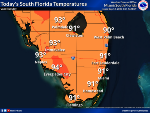
 Tuesday features mostly sunny skies and some mid to late afternoon showers and storms in the East Coast metro area. The Gulf Coast will be sunny in the morning, with some clouds, showers, and storms developing in the afternoon. A moderate risk of dangerous rip currents is in place along the Palm Beach County coast, and the rip current risk will increase at all the Atlantic beaches by midweek. Highs on Tuesday will be mostly in the low 90s — but it will feel about 10 degrees hotter, so stay hydrated and out of the sun.
Wednesday will bring a mix of sun, clouds, and periods of showers and storms to the East Coast metro area. The Gulf Coast will start the day on the sunny side, but showers and storms will move in during the afternoon. Wednesday’s highs will be mostly in the low 90s, but a few locations could top out in the mid-90s.
Thursday will feature sunny skies in the morning. Look for some storms to develop in the afternoon and linger into the evening. Thursday’s highs will be in the low 90s.
Friday will begin with sun, clouds, and a few storms in the east coast metro area, but showers will move in during the afternoon. The Gulf Coast will see lots of sun in the morning and a storm or two in spots along the Gulf Coast. Friday’s highs will be in the low 90s.

Saturday’s forecast calls for a mix of sun, showers, and storms. Highs on Saturday will be near 90 degrees.
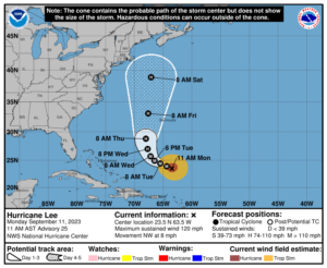 In the tropics, Hurricane Lee remains a powerful major hurricane and will not significantly weaken until after turning more to the north in a day or so. Swells from Lee are already creating hazardous surf conditions and dangerous rip currents along the U.S. East Coast, the Bahamas, and Bermuda and will continue all week.
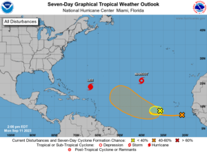 Elsewhere, Margot was on the verge of hurricane strength at midday on Monday, and it’s likely to remain a hurricane for a couple of days as it moves northward in the middle of the Atlantic. The wave in the eastern Atlantic is likely to become a depression by the weekend as it moves westward or west-northwestward into the central Atlantic. In the meantime, this wave is forecast to absorb a much weaker wave several hundred miles to its northwest, probably by the middle of the week.
Disclaimer
Artificial Intelligence Disclosure & Legal Disclaimer
AI Content Policy.
To provide our readers with timely and comprehensive coverage, South Florida Reporter uses artificial intelligence (AI) to assist in producing certain articles and visual content.
Articles: AI may be used to assist in research, structural drafting, or data analysis. All AI-assisted text is reviewed and edited by our team to ensure accuracy and adherence to our editorial standards.
Images: Any imagery generated or significantly altered by AI is clearly marked with a disclaimer or watermark to distinguish it from traditional photography or editorial illustrations.
General Disclaimer
The information contained in South Florida Reporter is for general information purposes only.
South Florida Reporter assumes no responsibility for errors or omissions in the contents of the Service. In no event shall South Florida Reporter be liable for any special, direct, indirect, consequential, or incidental damages or any damages whatsoever, whether in an action of contract, negligence or other tort, arising out of or in connection with the use of the Service or the contents of the Service.
The Company reserves the right to make additions, deletions, or modifications to the contents of the Service at any time without prior notice. The Company does not warrant that the Service is free of viruses or other harmful components.


