

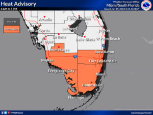
 Saturday features mostly sunny skies alternating with mainly afternoon and early evening showers and storms in the East Coast metro area. The Gulf Coast will be mostly sunny in the morning, but showers and storms in the afternoon will bring heavy rain. Highs on Saturday will be in the low 90s — but it will feel at least 10 degrees hotter, so stay hydrated and out of the sun.
Sunday will bring some sun, more clouds, and periods of showers to the East Coast metro area and the Keys. The Gulf Coast will see sun and storms in the morning and plenty of showers in the afternoon. Sunday’s highs will be in the upper 80s in the East Coast metro area and the Keys and in the low 90s along the Gulf Coast.
Monday will feature a mix of sun and showers in the East Coast metro area, while the Gulf Coast will see mostly sunny skies with morning storms and afternoon showers. Look for clouds and showers in the Keys. Monday’s highs will be mostly in the low 90s on the mainland and the upper 80s in the Keys.
Tuesday will be mostly sunny with periods of showers and storms. Tuesday’s highs will be in the low 90s in the East Coast metro area and the upper 80s in the Keys.

Wednesday’s forecast calls for plenty of showers and storms and periods of sun. Highs on Wednesday will be in the low 90s on the mainland and near 90 degrees in the Keys.

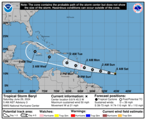 The tropical Atlantic is busy, and we’re keeping a very close eye on the wave that became Tropical Storm Beryl in the central Atlantic late Friday. At that time, Beryl was located east-southeast of Barbados and was moving west at 21 miles per hour. Maximum sustained winds were 50 miles per hour. Its future track brings it near Hispaniola, Jamaica, and portions of Cuba next week.
Elsewhere, the area of low pressure stretching from the western Caribbean to the southwestern Gulf of Mexico has a low chance of developing, but it will bring heavy rain to portions of Mexico and Central America this weekend.
And if that’s not enough, there’s another wave south-southwest of the Cabo Verde Islands. This wave has a low chance of development as it moves westward, but we’ll keep an eye on it as well.
Disclaimer
The information contained in South Florida Reporter is for general information purposes only.
The South Florida Reporter assumes no responsibility for errors or omissions in the contents of the Service.
In no event shall the South Florida Reporter be liable for any special, direct, indirect, consequential, or incidental damages or any damages whatsoever, whether in an action of contract, negligence or other tort, arising out of or in connection with the use of the Service or the contents of the Service. The Company reserves the right to make additions, deletions, or modifications to the contents of the Service at any time without prior notice.
The Company does not warrant that the Service is free of viruses or other harmful components


