

Monday features good sun and some clouds at times with an afternoon shower or storm in spots. Expect a moderate risk of dangerous rip currents along the Palm Beach County coast. Highs on Monday will be mostly in the low 90s.
Tuesday will bring mostly sunny skies, mainly afternoon and early evening showers and storms in the East Coast metro area. The Gulf Coast will be sunny in the morning with some storms developing in the afternoon and early evening. Look for clouds and showers in the Keys. Tuesday’s highs will be near 90 degrees in the East Coast metro area and the Keys and in the low 90s along the Gulf Coast.
Wednesday will feature breezy conditions with clouds, showers, and storms as tropical moisture reaches South Florida. Wednesday’s highs will be near 90 degrees in the East Coast metro area and the Keys and in the low 90s along the Gulf Coast.
Thursday’s forecast will depend on the track and strength of an area of disturbed weather forming in the western Caribbean. For now, we’ll say Thursday will be windy with plenty of clouds and periods of showers and storms. Thursday’s highs will be in the upper 80s.

Friday’s forecast will also depend on what happens to that potential disturbance. For now, Friday looks to be breezy with more clouds than sun and periods of showers and storms. Highs on Friday will be near 90 degrees in the East Coast metro area and in the upper 80s along the Gulf Coast and in the Keys.
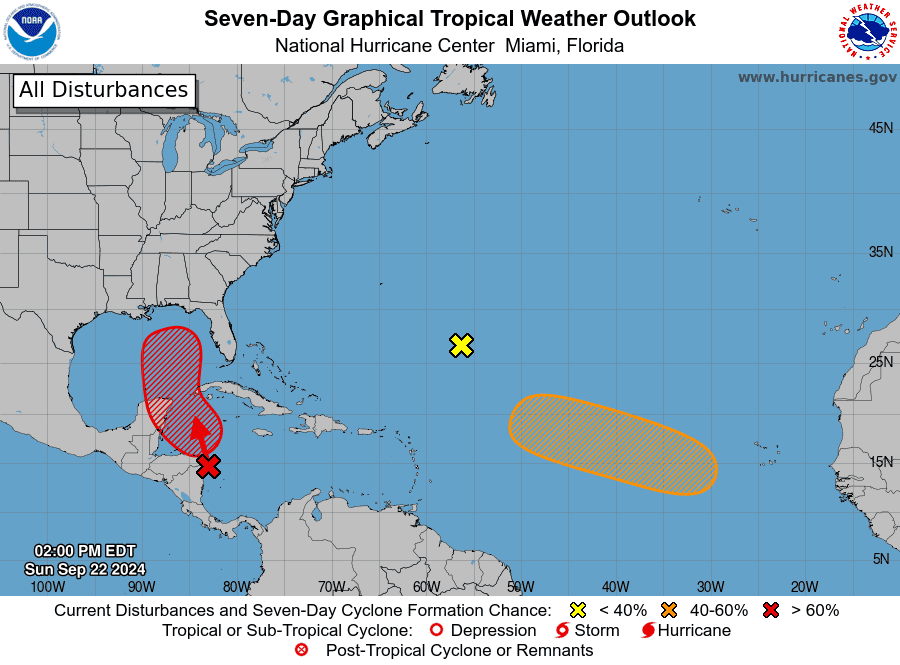 In the tropics, a disturbance appears to be forming in a broad area of low pressure in the western Caribbean near the coast of Central America. This feature has a high chance of becoming a depression in the next few days, and it definitely will bring heavy rain and gusty winds to portions of Central America. It is forecast to enter the Gulf of Mexico, but its track beyond that is uncertain. It appears certain that it will bring unsettled weather and potentially heavy rain to South Florida during the second half of the workweek. We’ll keep a very close eye on all this — and you should be dusting off your hurricane plan and checking your supplies, just in case.
Elsewhere, the area of low pressure several hundred miles southeast of Bermuda is nor expected to develop, while a wave emerging into the eastern Atlantic has a medium chance of becoming a depression as it moves west-northwestward across open waters.
Disclaimer
Artificial Intelligence Disclosure & Legal Disclaimer
AI Content Policy.
To provide our readers with timely and comprehensive coverage, South Florida Reporter uses artificial intelligence (AI) to assist in producing certain articles and visual content.
Articles: AI may be used to assist in research, structural drafting, or data analysis. All AI-assisted text is reviewed and edited by our team to ensure accuracy and adherence to our editorial standards.
Images: Any imagery generated or significantly altered by AI is clearly marked with a disclaimer or watermark to distinguish it from traditional photography or editorial illustrations.
General Disclaimer
The information contained in South Florida Reporter is for general information purposes only.
South Florida Reporter assumes no responsibility for errors or omissions in the contents of the Service. In no event shall South Florida Reporter be liable for any special, direct, indirect, consequential, or incidental damages or any damages whatsoever, whether in an action of contract, negligence or other tort, arising out of or in connection with the use of the Service or the contents of the Service.
The Company reserves the right to make additions, deletions, or modifications to the contents of the Service at any time without prior notice. The Company does not warrant that the Service is free of viruses or other harmful components.


")


")

")