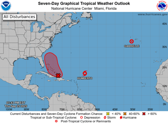
After an unusually slow start to the 2025 Atlantic hurricane season, forecasters at the National Hurricane Center are monitoring a complex situation with high stakes for the Southeast.
As of Thursday morning, Category 1 Hurricane Gabrielle was tracking east away from the U.S. and toward the Azores, an archipelago in the mid-Atlantic. Meanwhile, two developing storm systems in the western Atlantic are showing potential to rapidly strengthen and perhaps even interact, which could bring significant impacts to the Southeast coast.
Potential interaction between Humberto and Invest 94L
 Tropical Storm Humberto took shape in the central Atlantic on Wednesday and is now located several hundred miles northeast of the Leeward Islands. Though Humberto does not pose a direct threat to the U.S., the NHC expects it to rapidly strengthen over the next couple days as it tracks west-northwest, potentially reaching hurricane status by Friday evening.
Disclaimer
Artificial Intelligence Disclosure & Legal Disclaimer
AI Content Policy.
To provide our readers with timely and comprehensive coverage, South Florida Reporter uses artificial intelligence (AI) to assist in producing certain articles and visual content.
Articles: AI may be used to assist in research, structural drafting, or data analysis. All AI-assisted text is reviewed and edited by our team to ensure accuracy and adherence to our editorial standards.
Images: Any imagery generated or significantly altered by AI is clearly marked with a disclaimer or watermark to distinguish it from traditional photography or editorial illustrations.
General Disclaimer
The information contained in South Florida Reporter is for general information purposes only.
South Florida Reporter assumes no responsibility for errors or omissions in the contents of the Service. In no event shall South Florida Reporter be liable for any special, direct, indirect, consequential, or incidental damages or any damages whatsoever, whether in an action of contract, negligence or other tort, arising out of or in connection with the use of the Service or the contents of the Service.
The Company reserves the right to make additions, deletions, or modifications to the contents of the Service at any time without prior notice. The Company does not warrant that the Service is free of viruses or other harmful components.


