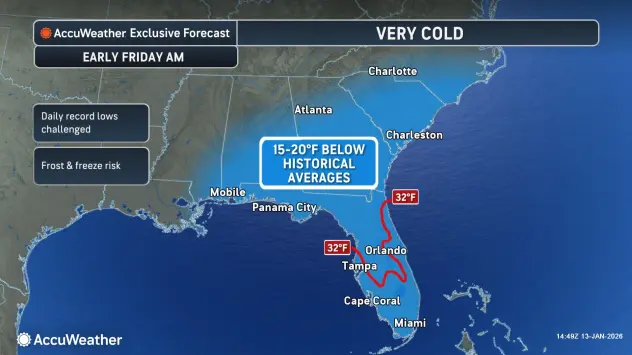
Residents across the Southeast are bracing for a dramatic shift in weather as a powerful cold front prepares to sweep through the region, ending a period of unseasonably warm conditions. After a start to 2026 that saw cities like Charlotte, Atlanta, and Jackson, Mississippi, averaging 11 to 13.5 degrees Fahrenheit above historical norms, a “potent cold front will move across the southeastern U.S. on Wednesday night and Thursday, bringing much cooler air to the region,” according to AccuWeather Senior Meteorologist Brett Anderson.
Temperatures may be 20 degrees below historical average later this week across the Southeast with a frost or freeze likely in areas of Florida. 🥶 https://t.co/lCfZS5vMC9 pic.twitter.com/ttmFhZ4gTO
— AccuWeather (@accuweather) January 13, 2026
This shift marks a return to true winter conditions, with high temperatures on Thursday afternoon expected to be as much as 25 degrees lower than those recorded earlier in the week. While the first half of January felt like spring for many, the incoming air mass will send temperatures into the 30s in Nashville and Atlanta. Further south, New Orleans and Tallahassee are bracing for highs only in the lower 50s.
The most significant impact of this cold snap will be felt in Florida, where the drop in temperature is expected to be extreme. While northern Florida may begin feeling the chill as early as Tuesday, the coldest air will arrive Thursday night. Major hubs like Jacksonville and Tallahassee are forecast to see lows dip into the 20s. Central Florida will not be spared, as Orlando and Lakeland are expected to see temperatures drop into the 30s.
The threat of frost and freezing conditions is a primary concern for the Sunshine State. Regarding the specific risks to the citrus and agriculture-heavy regions of the peninsula, AccuWeather Senior Meteorologist Dave Houk warned that “interior areas of central Florida are likely to have a freeze Thursday night.” This freeze marks the first significant cold event for the region since the final days of 2025.
Beyond the immediate freeze, the broader weather pattern suggests this chill will be persistent. A southward dip in the jet stream is expected to funnel waves of cold air and snow into the Great Lakes and Northeast throughout much of the month. While the Gulf Coast states are unlikely to see accumulating snow, the Appalachians of North Carolina and Tennessee should prepare for wintry accumulation.
For Florida and the Southeast, the “January Thaw” has officially ended. Meteorologists indicate that this weather pattern will persistently bring a chill into at least early next week, a stark reminder that winter has returned in full force. Residents are advised to take precautions to protect sensitive vegetation, outdoor pets, and exposed plumbing as the mercury drops well below historical averages.
Source: AccuWeather
Disclaimer
Artificial Intelligence Disclosure & Legal Disclaimer
AI Content Policy.
To provide our readers with timely and comprehensive coverage, South Florida Reporter uses artificial intelligence (AI) to assist in producing certain articles and visual content.
Articles: AI may be used to assist in research, structural drafting, or data analysis. All AI-assisted text is reviewed and edited by our team to ensure accuracy and adherence to our editorial standards.
Images: Any imagery generated or significantly altered by AI is clearly marked with a disclaimer or watermark to distinguish it from traditional photography or editorial illustrations.
General Disclaimer
The information contained in South Florida Reporter is for general information purposes only.
South Florida Reporter assumes no responsibility for errors or omissions in the contents of the Service. In no event shall South Florida Reporter be liable for any special, direct, indirect, consequential, or incidental damages or any damages whatsoever, whether in an action of contract, negligence or other tort, arising out of or in connection with the use of the Service or the contents of the Service.
The Company reserves the right to make additions, deletions, or modifications to the contents of the Service at any time without prior notice. The Company does not warrant that the Service is free of viruses or other harmful components.


