

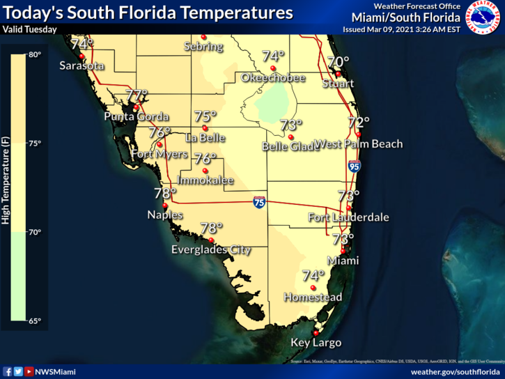
 Tuesday features a strong and gusty breeze throughout the day, along with lots of sun and a few clouds. A high risk of dangerous rip currents remains along the Atlantic coast through Thursday evening. Highs on Tuesday will be in the mid-70s in the east coast metro area and the upper 70s along the Gulf Coast.
LIVE RADAR 24/7 (Click Here Then Press Play)
Wednesday will be breezy again, and we’ll see good sun, some clouds, and the chance of a stray east coast shower. Wednesday’s highs will be in the upper 70s in the east coast metro area and near 80 degrees along the Gulf Coast.
Thursday will bring lots of sun and a strong and gusty ocean breeze. Thursday’s highs will be in the upper 70s in the east coast metro area, while highs will top out in the low 80s along the Gulf Coast.

Friday will feature good sun and a few clouds on a brisk ocean breeze (with gusty conditions at the Atlantic Coast). Friday’s highs will be in the low 80s.
Saturday’s forecast calls for lots of sun. Daylight Saving Time starts early Sunday morning, so move your clocks forward one hour on Saturday night. Highs on Saturday will be in the low 80s.
Disclaimer
The information contained in South Florida Reporter is for general information purposes only.
The South Florida Reporter assumes no responsibility for errors or omissions in the contents of the Service.
In no event shall the South Florida Reporter be liable for any special, direct, indirect, consequential, or incidental damages or any damages whatsoever, whether in an action of contract, negligence or other tort, arising out of or in connection with the use of the Service or the contents of the Service. The Company reserves the right to make additions, deletions, or modifications to the contents of the Service at any time without prior notice.
The Company does not warrant that the Service is free of viruses or other harmful components


