

For months, the Sunshine State has lived under the shadow of a relentless dry spell, watching as lawns turned to straw, lake levels receded, and the threat of wildfire loomed over its vast pine barrens and scrublands. However, a significant shift in the atmospheric pattern is finally underway. A slow-moving rainstorm is currently traversing the Florida peninsula, promising to deliver the most substantial moisture the region has seen in months. While the arrival of rain is being celebrated by agriculturists and forestry officials, meteorologists warn that the nature of this storm—its sluggish movement—brings distinct hazards, including localized urban flooding and dangerous conditions along the Atlantic coastline.
A Historic Drought Meets a Persistent Storm
 The scale of the current moisture deficit in Florida is difficult to overstate. According to recent climate data, the state is currently grappling with its worst drought in a quarter-century. Since the start of 2026, many regions have received only a fraction of their typical rainfall, with some areas reporting totals that are 25% to 33% below their long-term averages. This prolonged period of dryness has left approximately 80% of the state under “severe” or “extreme” drought conditions, the two most critical categories tracked by the U.S. Drought Monitor.
This week’s storm system represents a major break in that pattern. Unlike the fast-moving cold fronts that typically zip across the state during the winter months, this system is stalling, allowing moisture-rich air from the Atlantic and the Gulf of Mexico to pool over the peninsula. AccuWeather Senior Meteorologist Brett Anderson noted the potential for this system to provide meaningful relief to the areas that need it most.
“Our team of forecasters expects 1-2 inches of rain along the Florida Atlantic coast and across much of South Florida from Monday to Thursday, which will be good news for areas under severe to extreme drought,” Anderson said. “However, some locations could see repeating thunderstorms deliver 4-6 inches of rain, which may lead to flooding in poor drainage areas.”

The Geography of the Rain: From the Panhandle to the Keys
The impact of this slow-moving storm will be felt differently across the state’s diverse geography. In the northern counties and the Panhandle, where the drought has been particularly acute, the rain is seen as a lifeline for local ecosystems. Streams and river levels in these regions have plummeted to historic lows, affecting both local wildlife and municipal water supplies.
In Central Florida, including the Orlando metropolitan area and the I-4 corridor, the rain will likely be intermittent but heavy. This region is a hub for tourism, and while the rain is necessary, it poses challenges for the outdoor theme parks and resorts that drive the local economy. Visitors are advised to prepare for “washout” conditions during the peak afternoon hours, as atmospheric instability triggers training thunderstorms—cells that follow one another along the same path, like cars on a train track.
South Florida, including Miami-Dade and Broward counties, faces a unique set of challenges. Because much of South Florida sits just above sea level and relies on a complex system of canals and pumps to manage water, the 4-6 inches of rain forecast for certain areas by AccuWeather could quickly overwhelm drainage infrastructure. Miami, in particular, is prone to “sunny day flooding” even without rain; when a slow-moving storm is added to the mix, the risk of street flooding increases significantly.
Mitigating the Wildfire Risk
One of the most critical benefits of this week’s rain is the immediate reduction in wildfire risk. Florida’s wildfire season typically peaks in the spring when rising temperatures coincide with the tail end of the dry season. The parched vegetation acts as a ready fuel source for lightning-induced fires or accidental human-caused ignitions.
The incoming moisture will help “green up” the landscape, increasing the fuel moisture content in forests and grasslands. This makes it much harder for fires to start and, more importantly, much easier for firefighters to contain them if they do break out. Forestry officials have been on high alert, and while this single storm system will not completely erase the long-term drought, it provides a much-needed buffer as the state moves toward its traditional summer rainy season.
However, the relief is not uniform. Areas further north, particularly in southern Georgia and parts of the Carolinas, are expected to miss out on the heaviest totals from this specific system. In these regions, dry, breezy weather may actually escalate wildfire risk even as Florida receives its soaking.
Coastal Hazards and the Atlantic Beach Forecast
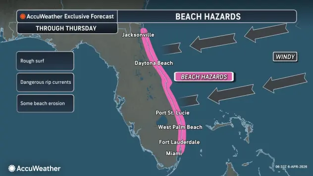 While the interior of the state deals with rain and humidity, the coastlines will experience the storm’s “fringe effects.” A long-duration onshore wind event is currently unfolding along the Atlantic beaches. With winds averaging 15-30 mph and gusts up to 40 mph possible, the surf is becoming increasingly rough.
Brett Anderson highlighted the specific dangers this poses to residents and tourists alike. “This long-duration onshore wind event will bring rough surf and dangerous rip currents as many people vacation in the state and locals return to the beaches,” Anderson warned. “Beach erosion and minor street flooding are possible, especially around high tide, including in Miami.”
Fortunately, the timing of the storm avoids a collision with “King Tides”—the highest astronomical tides of the year—which are not scheduled to occur until the third week of April. Had this storm arrived two weeks later, the combination of storm surge, onshore winds, and King Tides could have resulted in significant coastal inundation.
The Science Behind the Sluggish Storm
From a meteorological perspective, the behavior of this storm is a classic example of an “omega block” or a stalled front. Typically, the jet stream—a river of fast-moving air high in the atmosphere—acts as a conveyor belt, pushing weather systems along from west to east. When the jet stream develops large, stationary loops, weather systems can become trapped in place.
In this instance, a plume of tropical moisture has been tapped and is being funneled directly over Florida. Because there is no strong atmospheric “push” to move the system out into the Atlantic, the clouds simply linger. This results in the “repeating thunderstorms” Anderson mentioned. When a storm moves slowly, it has more time to dump its moisture over a single spot, which is the primary driver of the localized flooding concerns.
Economic and Agricultural Implications
Florida’s agricultural sector is watching the skies with a mix of relief and caution. The citrus industry, which has been battered by both disease and extreme weather in recent years, desperately needs the water to support the current growing cycle. However, excessive rain in a short period can also lead to root issues and fungal growth if the water does not drain properly.
For the cattle industry in Central and North Florida, the rain will help rejuvenate pastures that have been dormant and brown for months. This reduces the need for supplemental hay and lowers ranchers’ operational costs.
The tourism sector, meanwhile, may see a slight dip in daily revenue as outdoor activities are curtailed. Nevertheless, industry experts note that a “wet” Florida is a more attractive long-term prospect than a Florida under a permanent burn ban with smoky skies and receding lakes.
Looking Ahead: The 2026 Hurricane Season
This spring storm serves as a precursor to the upcoming 2026 Atlantic hurricane season. AccuWeather has already released its initial forecast for the season, predicting 11 to 16 named storms. While the current rainstorm is not tropical in nature, it is a reminder of the state’s vulnerability to water-based hazards.
The soil’s saturation this week means that, should a tropical system approach early in the season, the ground will have less capacity to absorb additional water. This “priming” of the landscape is a factor that emergency managers track closely throughout the year.
Safety Tips for Residents
As the rain continues through Thursday, officials are urging residents to take several precautions:
- Avoid Driving Through Flooded Streets: “Turn around, don’t drown” remains the primary advice. It only takes a few inches of moving water to sweep a vehicle off the road.
- Monitor Saturated Ground: In areas with significant tree cover, saturated ground combined with gusty winds can lead to downed trees and power lines.
- Stay Out of the Water: Beachgoers should heed red flag warnings. Rip currents are “silent killers” and can pull even the strongest swimmers away from the shore.
- Check Drainage: Homeowners are encouraged to clear gutters and storm drains of debris to ensure that the heavy rainfall has a clear path away from their property.
Conclusion
The slow-moving rainstorm currently drenching Florida is a double-edged sword. It is the definitive answer to a 25-year record drought and a critical shield against a burgeoning wildfire season. Yet, the very persistence that makes it so effective at replenishing the water table also makes it a threat to urban infrastructure and coastal safety.
As the system gradually pulls away toward the end of the week, the state will likely emerge with a much greener landscape and a significantly lower fire risk. For a state that defines itself by its relationship with water and sun, this week is a potent reminder of the power of the atmospheric cycles that sustain it. While the rain may spoil a few afternoon plans, the long-term health of Florida’s ecosystems depends on these moments of deluge.
Sources and Links:
Disclaimer
Artificial Intelligence Disclosure & Legal Disclaimer
AI Content Policy.
To provide our readers with timely and comprehensive coverage, South Florida Reporter uses artificial intelligence (AI) to assist in producing certain articles and visual content.
Articles: AI may be used to assist in research, structural drafting, or data analysis. All AI-assisted text is reviewed and edited by our team to ensure accuracy and adherence to our editorial standards.
Images: Any imagery generated or significantly altered by AI is clearly marked with a disclaimer or watermark to distinguish it from traditional photography or editorial illustrations.
General Disclaimer
The information contained in South Florida Reporter is for general information purposes only.
South Florida Reporter assumes no responsibility for errors or omissions in the contents of the Service. In no event shall South Florida Reporter be liable for any special, direct, indirect, consequential, or incidental damages or any damages whatsoever, whether in an action of contract, negligence or other tort, arising out of or in connection with the use of the Service or the contents of the Service.
The Company reserves the right to make additions, deletions, or modifications to the contents of the Service at any time without prior notice. The Company does not warrant that the Service is free of viruses or other harmful components.

")

")


")