

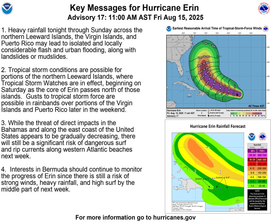
Erin became the first hurricane of the 2025 Atlantic season late Friday morning. Further strengthening is expected this weekend.
At 11 am Friday, Hurricane Erin was located about 460 miles east of the northern Leeward Islands. Maximum sustained winds were 75 miles per hour, and Erin was moving west-northwest at 18 miles per hour. Tropical storm watches remain for some of the Leeward Islands, and watches are possible later for the Virgin Islands and part of Puerto Rico.
Erin is forecast to turn to the northwest this weekend, keeping it east of the Bahamas.

Disclaimer
Artificial Intelligence Disclosure & Legal Disclaimer
AI Content Policy.
To provide our readers with timely and comprehensive coverage, South Florida Reporter uses artificial intelligence (AI) to assist in producing certain articles and visual content.
Articles: AI may be used to assist in research, structural drafting, or data analysis. All AI-assisted text is reviewed and edited by our team to ensure accuracy and adherence to our editorial standards.
Images: Any imagery generated or significantly altered by AI is clearly marked with a disclaimer or watermark to distinguish it from traditional photography or editorial illustrations.
General Disclaimer
The information contained in South Florida Reporter is for general information purposes only.
South Florida Reporter assumes no responsibility for errors or omissions in the contents of the Service. In no event shall South Florida Reporter be liable for any special, direct, indirect, consequential, or incidental damages or any damages whatsoever, whether in an action of contract, negligence or other tort, arising out of or in connection with the use of the Service or the contents of the Service.
The Company reserves the right to make additions, deletions, or modifications to the contents of the Service at any time without prior notice. The Company does not warrant that the Service is free of viruses or other harmful components.


