

Tuesday features some sun, more clouds, and periods of showers and storms, especially in the afternoon and evening. Expect an elevated risk of dangerous rip currents at the Atlantic beaches on Tuesday and most of the workweek. Highs on Tuesday will be mostly in the low 90s — but it will feel about 10 degrees hotter, so stay hydrated and out of the sun.
Wednesday will bring partly cloudy skies and plenty of showers and storms working their way from the East Coast to the Gulf during the morning and afternoon. Wednesday’s highs will be near 90 degrees in the East Coast metro area and the Keys and in the low 90s along the Gulf Coast.
Thursday will feature clouds and some storms in the morning, followed by plenty of showers in the afternoon and evening. Thursday’s highs will be in the low 90s.

Friday will see a mix of sun, clouds, showers, and storms in the East Coast metro area, while the Gulf Coast will be mostly sunny in the morning with showers and storms developing in the afternoon and lingering into the evening. plenty of showers and storms with periods of sun. Friday’s highs will be in the low 90s.
Saturday’s forecast calls for a mix of sun and clouds with periods of showers and storms. Highs on Saturday will be in the low 90s again.
 As expected, Potential Tropical Cyclone # 6 is now Tropical Storm Francine — and it’s quickly becoming better organized. Early Monday evening, TS Francine had maximum sustained winds of 65 miles per hour and it was moving north-northwest at 7 miles per hour. At that time, Francine was about 425 miles south-southwest of Cameron, Louisiana. There’s a hurricane warning for the Louisiana coast from Cameron to Grand Isle. There’s a tropical storm warning for the rest of the Louisiana coast and portions of the Texas coast, as well as a tropical storm watch for the northeastern coast of Mexico. Francine is forecast to become a hurricane well before landfall on the northern Gulf coast on Wednesday.
 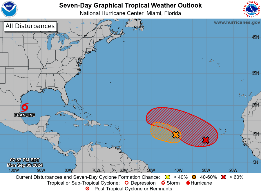 Elsewhere, the area of low pressure in the central Atlantic has a medium chance of becoming a depression as it moves slowly to the west-northwest this week. And the trough of low pressure several hundred miles west-southwest of the Cabo Verde Islands has a high chance of developing as it tracks to the west-northwest.
Disclaimer
Artificial Intelligence Disclosure & Legal Disclaimer
AI Content Policy.
To provide our readers with timely and comprehensive coverage, South Florida Reporter uses artificial intelligence (AI) to assist in producing certain articles and visual content.
Articles: AI may be used to assist in research, structural drafting, or data analysis. All AI-assisted text is reviewed and edited by our team to ensure accuracy and adherence to our editorial standards.
Images: Any imagery generated or significantly altered by AI is clearly marked with a disclaimer or watermark to distinguish it from traditional photography or editorial illustrations.
General Disclaimer
The information contained in South Florida Reporter is for general information purposes only.
South Florida Reporter assumes no responsibility for errors or omissions in the contents of the Service. In no event shall South Florida Reporter be liable for any special, direct, indirect, consequential, or incidental damages or any damages whatsoever, whether in an action of contract, negligence or other tort, arising out of or in connection with the use of the Service or the contents of the Service.
The Company reserves the right to make additions, deletions, or modifications to the contents of the Service at any time without prior notice. The Company does not warrant that the Service is free of viruses or other harmful components.


")


")
