A developing tropical wind and rainstorm is expected to bring torrential rain, damaging winds, coastal flooding, and beach erosion from Florida through New England and into Atlantic Canada over the coming days, according to AccuWeather expert meteorologists.
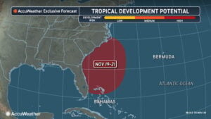
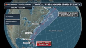
 The system is forecast to form near the northern Bahamas on Friday morning before moving northward along the Southeast coast Friday into Saturday. While disruptive wind shear may limit organization, the storm could develop tropical or subtropical characteristics—earning the name Kyle if it becomes a named tropical storm—and could rapidly intensify into a strong tropical storm or hurricane.

 Because of the combined threats of flooding rain, gusty winds, and coastal flooding, the storm is rated a 1 on the AccuWeather RealImpact™ Scale for Hurricanes in the United States and the Bahamas. Unlike the Saffir-Simpson Hurricane Wind Scale, which measures wind speed alone, the RealImpact™ Scale evaluates wind, rainfall, storm surge, and economic loss.
Months-Long Flooding Threatens Eastern Florida
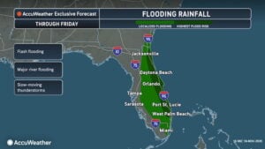
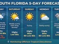
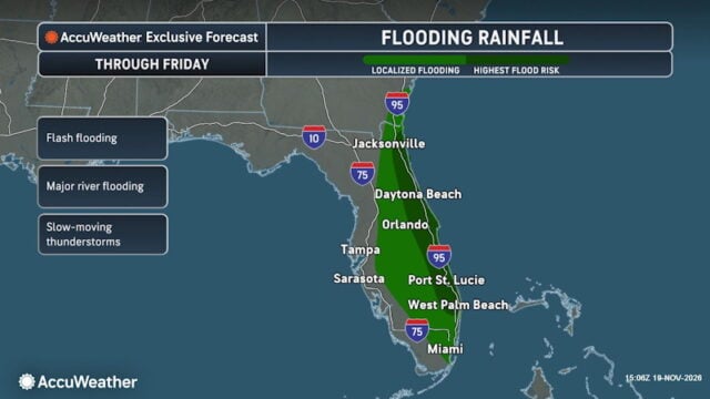
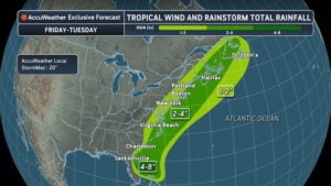
 Before moving up the coast, slow-moving rain and thunderstorms will drench eastern Florida through Friday, adding water to already saturated ground. Along Florida’s Atlantic coast from Melbourne to St. Augustine, 12 to 18 inches of rain is forecast, with an AccuWeather Local StormMax™ of 24 inches. Farther south, Florida’s Space Coast could see 4 to 8 inches, with localized totals up to 20 inches, while West Palm Beach and surrounding areas face renewed flooding after receiving over 12 inches in 48 hours earlier this month.
Torrential rainfall overwhelming the St. Johns River system could leave homes and businesses inundated well into 2027. Portions of the river could reach or exceed the historic flooding benchmark set in 1953. Because the river drops an average of just 1 inch per mile across roughly 300 miles, floodwaters drain extremely slowly—a pattern that left communities flooded for weeks after Hurricane Irma in 2017 and Hurricane Ian in 2022.
“The rain may stop, but the flooding could last for months,” said AccuWeather expert meteorologist Alex Sosnowski. “Water drains so slowly through the St. Johns River system that some homes and businesses could remain inundated into 2027, even if no additional rain falls through the end of the year.”
AccuWeather expert meteorologist William Clark added that El Niño favors more frequent heavy rain events across Florida during winter, which could further prolong flooding and delay recovery. Residents along the river and connected lakes are urged to prepare for extended disruptions and follow local evacuation orders.
Timeline and Impacts for the Carolinas, Mid-Atlantic, and Northeast
 As the storm tracks over the warm Gulf Stream waters, its exact path will determine how severely coastal communities from Georgia to Atlantic Canada are affected. A track closer to shore will bring heavier rain and stronger winds inland, whereas a path farther offshore would substantially reduce wind and rain threats.
“This storm could look very different by the time it reaches the Carolinas and New England than it does when it first develops near the Bahamas,” said AccuWeather expert meteorologist Carl Erickson. “Some of the strongest winds could develop farther north, where gusts may be strong enough to bring down trees and knock out power.”
 AccuWeather meteorologists are tracking the following regional hazards:
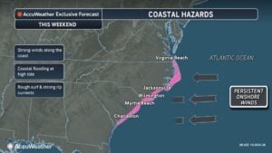
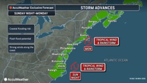
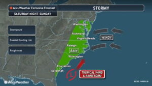
- Storm Timing and Track: Impacts will reach coastal Georgia and the Carolinas over the weekend, affecting Wilmington, the Outer Banks, and Virginia Beach Saturday into Sunday. Rain and wind could reach the Delmarva Peninsula, Atlantic City, New York City, and Boston Sunday into Monday—bringing nor’easter-like conditions to New England—before moving toward Atlantic Canada Monday into Tuesday.
- Vulnerable Outer Banks: Portions of North Carolina’s Outer Banks have already suffered severe beach erosion and coastal flooding this year. “Additional impacts, especially to North Carolina Highway 12 on Hatteras Island, could lead to road closures,” said AccuWeather Senior Meteorologist Alan Reppert. Prolonged onshore winds could also push water into the Pamlico and Albemarle Sounds, raising flood risks when winds shift and push water back toward the ocean.
- Damaging Wind Gusts: Widespread gusts of 40 to 60 mph are expected from coastal South Carolina through southern New England and Atlantic Canada. Coastal North Carolina and far southeastern Massachusetts could experience gusts of 60 to 80 mph, with an AccuWeather Local StormMax™ of 90 mph capable of downing trees and causing localized power outages.
- Additional Rainfall: Beyond Florida, widespread rainfall of 1 to 2 inches is forecast from the Southeast through Atlantic Canada, with 2 to 4 inches possible across eastern North Carolina, far southeastern New England, and Atlantic Canada.
Whether the system receives an official tropical designation, rough surf, coastal flooding, and strong winds remain the primary hazards along the Eastern Seaboard into early next week.
Disclaimer
Artificial Intelligence Disclosure & Legal Disclaimer
AI Content Policy.
To provide our readers with timely and comprehensive coverage, South Florida Reporter uses artificial intelligence (AI) to assist in producing certain articles and visual content.
Articles: AI may be used to assist in research, structural drafting, or data analysis. All AI-assisted text is reviewed and edited by our team to ensure accuracy and adherence to our editorial standards.
Images: Any imagery generated or significantly altered by AI is clearly marked with a disclaimer or watermark to distinguish it from traditional photography or editorial illustrations.
General Disclaimer
The information contained in South Florida Reporter is for general information purposes only.
South Florida Reporter assumes no responsibility for errors or omissions in the contents of the Service. In no event shall South Florida Reporter be liable for any special, direct, indirect, consequential, or incidental damages or any damages whatsoever, whether in an action of contract, negligence or other tort, arising out of or in connection with the use of the Service or the contents of the Service.
The Company reserves the right to make additions, deletions, or modifications to the contents of the Service at any time without prior notice. The Company does not warrant that the Service is free of viruses or other harmful components.