

Monday features breezy conditions, mostly sunny skies, some morning showers, and afternoon storms in the East Coast metro area. The Gulf coast will be mostly sunny and breezy with a few afternoon storms. Look for sun, clouds, and some showers in the Keys. A high risk of dangerous rip currents remains at the Atlantic beaches through at least Monday evening. Highs on Monday will be in the upper 80s right at the Atlantic coast and in the Keys, near 90 degrees along the Gulf coast, and in the low 90s elsewhere in South Florida.
Tuesday will bring sun, clouds, and some showers and storms on a brisk breeze to the east coast metro area. The Gulf coast will be sunny in the morning, with clouds and a few showers and storms developing in the afternoon. The Keys will see good sun, a few clouds, and a shower in spots. Tuesday’s highs will be mostly in the low 90s in the east coast metro area and in the upper 80s along the Gulf coast and in the Keys.
Wednesday will feature lots of sun in the morning on the mainland, with some clouds, showers, and storms moving in during the afternoon. The Keys will see a mix of sun and clouds. Wednesday’s highs will be near 90 degrees in the east coast metro area and in the upper 80s along the Gulf coast and in the Keys.
Thursday will start with sun and some showers in the east coast metro area, but showers and storms will develop in the afternoon. The Gulf coast will see a sunny morning, with showers and storms moving in during the afternoon. Look for clouds and showers in the Keys. Thursday’s highs will be in the upper 80s.

Friday’s forecast calls for a mix of sun, clouds, showers, and storms on the mainland, while the Keys will see mostly sunny skies. Highs on Friday will be in the upper 80s.
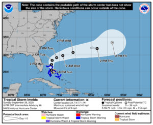 In the tropics, Tropical Storm Imelda is bringing tropical storm force winds and heavy rain to the central and northwestern Bahamas, where tropical storm warnings are in effect until at least Monday morning. Early Sunday evening, Imelda was about 55 miles south-southwest of the northwestern Bahamas and was moving north at 9 miles per hour. Maximum sustained winds were 40 miles per hour at that time, but strengthening is expected. The tropical storm watch in Florida from the Palm Beach/Martin county line to the Flagler/Volusia county line has been discontinued.
Imelda is forecast to become a hurricane once it turns away from the north Florida coast on Tuesday and moves in the direction of Bermuda. But the Atlantic coast from central Florida to North Carolina can expect dangerous rip currents, rough surf, and beach erosion for the next several days.
We’re also watching Hurricane Humberto, which could bring tropical storm conditions to Bermuda on Tuesday. Early Sunday evening, Humberto was about 470 miles south of Bermuda and was moving northwest at 13 miles per hour. Maximum sustained winds were 145 miles per hour at that time. There’s now a tropical storm watch for Bermuda for Humberto (and could be one later in the week for Imelda). Swells from Humberto will affect the U.S. east coast with dangerous rip currents and rough surf beginning on Monday.
Disclaimer
Artificial Intelligence Disclosure & Legal Disclaimer
AI Content Policy.
To provide our readers with timely and comprehensive coverage, South Florida Reporter uses artificial intelligence (AI) to assist in producing certain articles and visual content.
Articles: AI may be used to assist in research, structural drafting, or data analysis. All AI-assisted text is reviewed and edited by our team to ensure accuracy and adherence to our editorial standards.
Images: Any imagery generated or significantly altered by AI is clearly marked with a disclaimer or watermark to distinguish it from traditional photography or editorial illustrations.
General Disclaimer
The information contained in South Florida Reporter is for general information purposes only.
South Florida Reporter assumes no responsibility for errors or omissions in the contents of the Service. In no event shall South Florida Reporter be liable for any special, direct, indirect, consequential, or incidental damages or any damages whatsoever, whether in an action of contract, negligence or other tort, arising out of or in connection with the use of the Service or the contents of the Service.
The Company reserves the right to make additions, deletions, or modifications to the contents of the Service at any time without prior notice. The Company does not warrant that the Service is free of viruses or other harmful components.


")


