

Wednesday features breezy conditions, plenty of clouds, and periods of heavy rain. Look for showers during the day and in the evening in the East Coast metro area, and daytime showers and evening storms along the Gulf Coast. A flood watch is in effect until Thursday morning in the East Coast metro area. A high risk of dangerous rip currents is in effect at the Atlantic beaches through Friday morning. Highs on Wednesday will be in the upper 70s in the East Coast metro area and in the low 80s along the Gulf Coast and in the Keys.
Thursday will be breezy with daytime showers and evening storms in the East Coast metro area. The Gulf Coast will see a gusty breeze, plenty of clouds, morning showers, and some afternoon storms. Localized flooding is possible in spots. Thursday’s highs will be in the low 80s.
Friday will feature breezy conditions and a mix of sun, clouds, and some showers in the east coast metro area. The Gulf Coast will see plenty of sun and a cloud or two on a gusty breeze. Friday’s highs will be in the mid-80s.
Saturday will be mostly sunny in the East Coast metro area, while the Gulf Coast will continue to see lots of sun. Saturday’s highs will be mostly in the low 80s.

Sunday’s forecast calls for sunny skies around South Florida. Highs on Sunday will be in the low 80s.
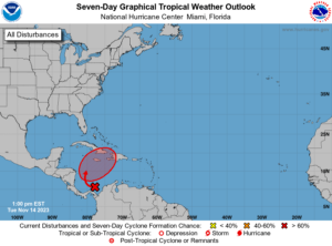 In the tropics, an area of low pressure is forming in the southwestern Caribbean. The National Hurricane Center gives it a high chance of becoming a depression late in the workweek or during the weekend. Computer models indicate this feature will move to the northeast and bring heavy rain and strong winds to Jamaica, eastern Cuba, Hispaniola, the Turks and Caicos, and the southeastern Bahamas. While the models also indicate this feature will remain well east of Florida, we’ll definitely keep an eye on it.
Disclaimer
Artificial Intelligence Disclosure & Legal Disclaimer
AI Content Policy.
To provide our readers with timely and comprehensive coverage, South Florida Reporter uses artificial intelligence (AI) to assist in producing certain articles and visual content.
Articles: AI may be used to assist in research, structural drafting, or data analysis. All AI-assisted text is reviewed and edited by our team to ensure accuracy and adherence to our editorial standards.
Images: Any imagery generated or significantly altered by AI is clearly marked with a disclaimer or watermark to distinguish it from traditional photography or editorial illustrations.
General Disclaimer
The information contained in South Florida Reporter is for general information purposes only.
South Florida Reporter assumes no responsibility for errors or omissions in the contents of the Service. In no event shall South Florida Reporter be liable for any special, direct, indirect, consequential, or incidental damages or any damages whatsoever, whether in an action of contract, negligence or other tort, arising out of or in connection with the use of the Service or the contents of the Service.
The Company reserves the right to make additions, deletions, or modifications to the contents of the Service at any time without prior notice. The Company does not warrant that the Service is free of viruses or other harmful components.


")

