

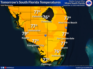
 Wednesday features breezy conditions, plenty of clouds, and periods of showers throughout the day. Evening showers are also likely in the East Coast metro area and much of the Keys. A high risk of dangerous rip currents remains at the Atlantic beaches through at least Thursday evening. Highs on Wednesday will be in the upper 70s.
Thursday will feature windy conditions, lots of clouds, and periods of showers. The East Coast metro area can expect the showers to last into the evening. Thursday’s highs will be in the mid-70s.
Friday will be windy with mostly cloudy skies and lots of showers — and not enough sun to really warm us up. Friday’s highs will be in the low 70s.
Saturday will be another windy and cloudy day. Look for periods of showers, especially in the east coast metro area. Saturday’s highs will be in the mid-70s.

Sunday’s forecast calls for yet another windy day with a mix of sun, clouds, and showers. Highs on Sunday will be in the mid-70s.
Disclaimer
The information contained in South Florida Reporter is for general information purposes only.
The South Florida Reporter assumes no responsibility for errors or omissions in the contents of the Service.
In no event shall the South Florida Reporter be liable for any special, direct, indirect, consequential, or incidental damages or any damages whatsoever, whether in an action of contract, negligence or other tort, arising out of or in connection with the use of the Service or the contents of the Service. The Company reserves the right to make additions, deletions, or modifications to the contents of the Service at any time without prior notice.
The Company does not warrant that the Service is free of viruses or other harmful components


")


