A relentless parade of Alberta Clipper storms is set to march across the central and eastern United States through early next week, ushering in a prolonged period of wintry weather, treacherous travel, and a record-breaking plunge in temperatures that will reach as far south as the Florida Peninsula.
The “Clipper Train” Hits the Midwest and Northeast
Meteorologists are tracking as many as three distinct clipper systems originating from central Canada. The first round, which began mid-week in the Great Lakes, is currently spreading into the Northeast. According to AccuWeather Meteorologist Brandon Buckingham, these back-to-back rounds of wintry weather will focus the heaviest accumulations on the interior Northeast and areas downwind of the Great Lakes.
“A foot or more of snow could pile up in areas downwind of the Great Lakes and across higher elevations by the end of the weekend,” Buckingham warned.
While the mountain ranges of the Appalachians, Poconos, and Catskills prepare for significant totals, the storm’s reach is extensive. A “plowable” snow is forecast for at least ten states, ranging from Michigan to Maine. Even the major metropolitan hubs of the I-95 corridor—including Washington, D.C., Philadelphia, and New York City—could see a coating of snow that may complicate the Monday morning commute.
Danger on the Roads: Flash Freezes and Snow Squalls
Beyond the total snowfall, the primary threat to life and property is the nature of these storms. The clippers are followed by reinforcing waves of Arctic air, creating a high risk for flash freezes. As temperatures plummet 20 to 25 degrees below historical averages, wet roads from earlier rain or melted snow will rapidly turn into sheets of ice.
“Road conditions can deteriorate rapidly when snow bands move through,” said Buckingham. “Sudden drops in visibility and slippery roads are a dangerous combination. Drivers should slow down and increase following distance.”
Heavy lake-effect snow is also expected to be a major factor. Downwind of the Great Lakes, totals could exceed 6 inches with each passing storm, with some localized “StormMax” totals reaching as high as 24 inches in parts of New York and Pennsylvania.
Florida Braces for Freezes and “Falling Iguanas”
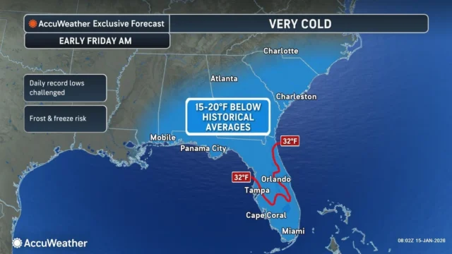
The cold front is not stopping at the Mason-Dixon line. By Friday morning, the Southeast will feel the full force of the Arctic air. High temperatures in Atlanta and Nashville are expected to struggle into the 30s, while Tallahassee and Jacksonville will see lows drop into the 20s.
Central Florida, including Orlando and Lakeland, is bracing for temperatures in the 30s. This poses a significant threat to the region’s sensitive citrus crops and tropical vegetation. However, the most unique hazard of this cold snap is the potential for falling iguanas.
“Green iguanas are sensitive to the cold and can become stunned when temperatures fall into the 40s and 30s,” Buckingham explained. “When that happens, they may lose their grip and fall from the trees. It’s a unique cold-weather hazard in Florida.” Officials warn residents not to touch the reptiles, as they are likely still alive and may become aggressive once they warm up.
Weekend Coastal Storm Development
As if the clippers weren’t enough, a new coastal storm is forecast to develop late Saturday. This system could bring a rare slushy mix of snow and rain to the Florida Panhandle and southern Georgia before tracking north toward the Mid-Atlantic.
The exact track remains uncertain, but meteorologists say even a small shift could bring significant snow to the I-95 corridor by Sunday night. Regions in the Deep South, often unequipped for snow removal, are particularly vulnerable to travel disruptions.
Looking Ahead: The Polar Vortex Tightens Its Grip
This active pattern is expected to persist through the end of January as the polar vortex remains unstable. A pronounced dip in the jet stream will continue to funnel Arctic air into the central and eastern U.S., with the potential for an even sharper blast of cold by early February.
Businesses and residents are encouraged to prepare for elevated energy demands and continued operational slowdowns. For now, the focus remains on the immediate threat of icy roads and the biting chill of the most significant winter event of 2026 so far.
Disclaimer
Artificial Intelligence Disclosure & Legal Disclaimer
AI Content Policy.
To provide our readers with timely and comprehensive coverage, South Florida Reporter uses artificial intelligence (AI) to assist in producing certain articles and visual content.
Articles: AI may be used to assist in research, structural drafting, or data analysis. All AI-assisted text is reviewed and edited by our team to ensure accuracy and adherence to our editorial standards.
Images: Any imagery generated or significantly altered by AI is clearly marked with a disclaimer or watermark to distinguish it from traditional photography or editorial illustrations.
General Disclaimer
The information contained in South Florida Reporter is for general information purposes only.
South Florida Reporter assumes no responsibility for errors or omissions in the contents of the Service. In no event shall South Florida Reporter be liable for any special, direct, indirect, consequential, or incidental damages or any damages whatsoever, whether in an action of contract, negligence or other tort, arising out of or in connection with the use of the Service or the contents of the Service.
The Company reserves the right to make additions, deletions, or modifications to the contents of the Service at any time without prior notice. The Company does not warrant that the Service is free of viruses or other harmful components.


