After weeks of destructive flooding and swollen rivers across the Southwest, millions of residents will finally get a break. Major storms will stay away from the region through at least mid-November. Parts of Southern California, New Mexico, Colorado, and Texas received two to 10 times their average rainfall since September. Clovis, New Mexico, recorded 28.48 inches of rain over six weeks, exceeding its typical annual total. A Halloween weekend atmospheric river sent Southwest rivers surging to historic levels and compounded earlier storm damage. Runoff will flow down the Colorado River, potentially raising water levels in Lake Powell and Lake Mead. AccuWeather experts note that drought-stricken reservoirs will still need many more winter rain and mountain snow storms.
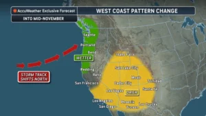 Meanwhile, the active storm track is shifting north toward the Pacific Northwest later this week. Forecasters expect repeated rounds of heavy rain across Washington, Oregon, and northern California. The initial system arrives before the week ends, followed by additional storms next week. A stronger storm late next week could bring more heavy rain and mountain snow. AccuWeather expert meteorologist Dan Pydynowski warned that back-to-back moderate storms can trigger major problems. Even though the region is accustomed to wet weather, communities remain vulnerable to significant flooding.
Several inches of rain could fall across Seattle, Vancouver, and the foothills of the Cascades. Urban areas face localized flooding, while mountain snow could disrupt travel across the Cascades and southwestern British Columbia. Heavy rain and high-elevation pass snow will likely slow commutes and freight deliveries along the Interstate 5 corridor.
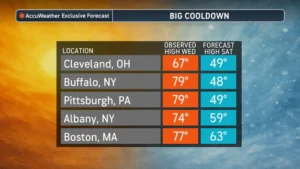
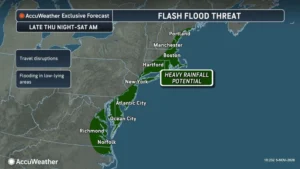 On the opposite coast, a separate storm system is bringing widespread rain from Virginia to Massachusetts. Downpours starting Thursday and lasting into early Saturday will end weeks of predominantly dry weather across the Northeast. Thursday’s showers will mix with road oil, dust, and fallen leaves, creating slick driving conditions. Atlantic moisture will enhance coastal rainfall Thursday night into Friday, raising flash flood risks from Virginia to Massachusetts. Eastern Long Island and southeastern Massachusetts could see two to four inches of rain. The AccuWeather Local StormMax for this event reaches six inches. Pydynowski noted that accumulated autumn leaves can block storm drains and flood streets rapidly. Drivers in New York City, Boston, Atlantic City, and Norfolk should prepare for localized street flooding and delays. Behind the storm, Saturday temperatures will plunge up to 30 degrees lower than Wednesday across the Great Lakes and Northeast. Highs will struggle to reach 50 degrees in Buffalo and Pittsburgh, while Cleveland tops out near 49 degrees.

 The Northeast rain arrives as Florida recovers from historic flooding that damaged infrastructure and relocated Election Day polling sites. AccuWeather preliminarily estimates total damage and economic loss in Florida between $3 billion and $5 billion. This comprehensive estimate evaluates insured and uninsured property losses, infrastructure damage, supply chain disruptions, evacuations, and cleanup expenses. Standard homeowners policies rarely cover water damage, and only 4% of American homeowners carry coverage through the National Flood Insurance Program.
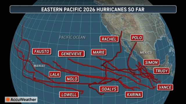
Much of this turbulent North American weather connects to a record-shattering eastern and central Pacific hurricane season. AccuWeather expert meteorologist Tyler Roys explained that El Niño’s warm waters and favorable winds fuel powerful, long-lasting Pacific hurricanes. Conversely, El Niño increases disruptive wind shear over the Atlantic basin. Through November 2, the Pacific recorded 76.25 active hurricane days, breaking the 2018 record of 68.25 days. Named storms remained active for a record 157.25 days, surpassing the 1992 mark of 153.7 days. Accumulated Cyclone Energy reached 354.1, beating the full-season record of 318.1 set in 2018. With 24 named storms, the 2026 season ties for third-most on record before ending November 30. Storms Lala, Lowell, and Nolo hit Hawaii, while Polo, Rachel, and Simon sent tropical moisture into Mexico and the Southwest.
Sources
- AccuWeather
- National Flood Insurance Program (FEMA)
- U.S. Bureau of Reclamation – Colorado River Basin
- NOAA National Centers for Environmental Information
- Tampa Free Press
Disclaimer
Artificial Intelligence Disclosure & Legal Disclaimer
AI Content Policy.
To provide our readers with timely and comprehensive coverage, South Florida Reporter uses artificial intelligence (AI) to assist in producing certain articles and visual content.
Articles: AI may be used to assist in research, structural drafting, or data analysis. All AI-assisted text is reviewed and edited by our team to ensure accuracy and adherence to our editorial standards.
Images: Any imagery generated or significantly altered by AI is clearly marked with a disclaimer or watermark to distinguish it from traditional photography or editorial illustrations.
General Disclaimer
The information contained in South Florida Reporter is for general information purposes only.
South Florida Reporter assumes no responsibility for errors or omissions in the contents of the Service. In no event shall South Florida Reporter be liable for any special, direct, indirect, consequential, or incidental damages or any damages whatsoever, whether in an action of contract, negligence or other tort, arising out of or in connection with the use of the Service or the contents of the Service.
The Company reserves the right to make additions, deletions, or modifications to the contents of the Service at any time without prior notice. The Company does not warrant that the Service is free of viruses or other harmful components.