 |
|
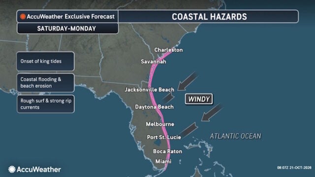
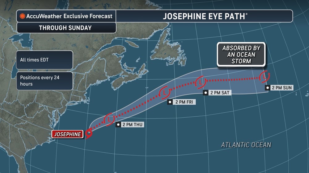
The window for Josephine to strengthen will close quickly as it encounters cooler water in the North Atlantic, but there is a small opportunity for intensification into Thursday and for it to strengthen into a hurricane before it loses any tropical characteristics. What to Expect from Josephine Josephine continues to produce strong winds, rough surf, coastal flooding and significant beach erosion over the mid-Atlantic and into southeast New England. The most significant coastal impacts have been from the Outer Banks of North Carolina and the Tidewater of Virginia, and these will lessen as the storm moves eastward across the North Atlantic Ocean over the next couple of days. The impact from high tides in the mid-Atlantic will gradually lessen through the rest of the week. AccuWeather hurricane experts currently do not expect the coastal flooding from Josephine to be as impactful along the New Jersey and southern New England coastlines when compared to the prior nor’easter in late September. There can still be minor flooding and beach erosion in this area. As Josephine moves northeastward across the Atlantic, it will brush the southeast New England coast with rain and gusty winds. This rain and wind will expand into Nova Scotia and Newfoundland through Friday. There can even be some wet snow across Newfoundland on Friday as the center of Josephine passes well to the southeast of Atlantic Canada. Wind Gusts Could Reach 75 MPH Josephine will bring a large swath of tropical-storm-force winds from coastal Nova Scotia through southern Newfoundland. Most of the strongest winds will be along the coastline, but some of these stronger wind gusts can extend into interior portions of Nova Scotia and Newfoundland, as well. Gusts of 40-60 mph will clip Atlantic Canada with an AccuWeather Local StormMax™of 75 mph. These wind gusts can bring down some trees and lead to localized power outages |

 |
 |
Disclaimer
Artificial Intelligence Disclosure & Legal Disclaimer
AI Content Policy.
To provide our readers with timely and comprehensive coverage, South Florida Reporter uses artificial intelligence (AI) to assist in producing certain articles and visual content.
Articles: AI may be used to assist in research, structural drafting, or data analysis. All AI-assisted text is reviewed and edited by our team to ensure accuracy and adherence to our editorial standards.
Images: Any imagery generated or significantly altered by AI is clearly marked with a disclaimer or watermark to distinguish it from traditional photography or editorial illustrations.
General Disclaimer
The information contained in South Florida Reporter is for general information purposes only.
South Florida Reporter assumes no responsibility for errors or omissions in the contents of the Service. In no event shall South Florida Reporter be liable for any special, direct, indirect, consequential, or incidental damages or any damages whatsoever, whether in an action of contract, negligence or other tort, arising out of or in connection with the use of the Service or the contents of the Service.
The Company reserves the right to make additions, deletions, or modifications to the contents of the Service at any time without prior notice. The Company does not warrant that the Service is free of viruses or other harmful components.