|
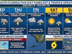
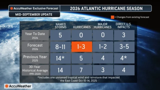
The Atlantic could produce its first hurricane of the season near Bermuda later this week, even as AccuWeather lowers its forecast for the total number of hurricanes expected in 2026 again. An area of disorganized showers and thunderstorms near Bermuda has a medium risk of tropical development from Sept. 17-21. Interests in Bermuda should closely monitor the area over the coming days. “If this system develops, it will likely move into an environment that is conducive for strengthening,” said AccuWeather expert meteorologist Nicholas Arman. “We cannot rule out this becoming the first hurricane of the Atlantic season should it develop. The combination of warm ocean water and favorable atmospheric conditions near Bermuda could allow the system to strengthen significantly if it becomes organized.” AccuWeather Lowers its Hurricane Forecast Following Historically Slow first half of the Season Despite the potential for a hurricane near Bermuda, the broader atmospheric conditions across the Atlantic continues to favor an unusually low number of hurricanes this season. AccuWeather now forecasts 1-3 hurricanes for the 2026 Atlantic hurricane season, down from the previous forecast of 3-4. “We have never gone this late into the Atlantic hurricane season without a hurricane in the satellite era,” AccuWeather lead hurricane expert Alex DaSilva explained. “The strengthening El Niño is a major reason we are lowering our forecast again. Increasing wind shear has made it extremely difficult for storms to organize and strengthen, and we expect those conditions to become even less favorable as El Niño strengthens.” |

 |
Disclaimer
Artificial Intelligence Disclosure & Legal Disclaimer
AI Content Policy.
To provide our readers with timely and comprehensive coverage, South Florida Reporter uses artificial intelligence (AI) to assist in producing certain articles and visual content.
Articles: AI may be used to assist in research, structural drafting, or data analysis. All AI-assisted text is reviewed and edited by our team to ensure accuracy and adherence to our editorial standards.
Images: Any imagery generated or significantly altered by AI is clearly marked with a disclaimer or watermark to distinguish it from traditional photography or editorial illustrations.
General Disclaimer
The information contained in South Florida Reporter is for general information purposes only.
South Florida Reporter assumes no responsibility for errors or omissions in the contents of the Service. In no event shall South Florida Reporter be liable for any special, direct, indirect, consequential, or incidental damages or any damages whatsoever, whether in an action of contract, negligence or other tort, arising out of or in connection with the use of the Service or the contents of the Service.
The Company reserves the right to make additions, deletions, or modifications to the contents of the Service at any time without prior notice. The Company does not warrant that the Service is free of viruses or other harmful components.