

The global climate system is flashing red as meteorologists track an exceptionally strong El Niño event building in the Pacific Ocean. While this atmospheric phenomenon is traditionally associated with heavy rainfall in specific zones, its broader, long-term implications are triggering severe alarms for America’s agricultural heartland. Climate experts are now warning that the conditions are aligning for a catastrophic, multi-year drought that could devastate crop yields, upend the agricultural economy, and critically compromise local water supplies.
According to long-range forecasting models, this El Niño began forming in early June 2026 and is projected to peak later this year, lingering well into 2027. What makes this cycle deeply concerning is its projected intensity. Meteorologists assign a 70% probability that this event will escalate into a “Super El Niño”—a classification reserved for only the most intense atmospheric cycles on record. History indicates that when an anomaly reaches this magnitude, the environmental hangover can persist for years, locking regions into an intractable pattern of extreme dryness long after the Pacific waters have cooled.
As seen in the graphic above, the weakening of equatorial trade winds allows a massive pool of warm water to shift eastward across the Pacific Ocean. This disruption completely alters the behavior of the jet stream, amplifying extreme weather patterns across the globe.
The Threat of a Multi-Year Cycle
While El Niño is widely known for delivering above-average precipitation across the southern United States during its winter peak, its northern and northwestern effects paint a completely different picture. Dryness and drought frequently grip parts of the Pacific Northwest and the northern tier of the nation during these events. However, the most insidious threat lies in the post-event recovery period for the Great Plains.

The historical record indicates that the stronger an El Niño becomes, the more violently it warps the baseline weather systems. “After El Niño ends, the following two to three years can end up being significantly drier in parts of the Plains from Texas into the Dakotas, which are already experiencing extreme drought conditions,” noted AccuWeather long-range expert Paul Pastelok. The structural persistence of these altered jet streams means that normalcy does not return overnight. Pastelok emphasized that “the stronger the upcoming El Niño conditions get, the longer it takes for weather patterns to return to their historical average.”
The Present Crisis: Deteriorating Plains Conditions
The true danger of the upcoming Super El Niño is that it is not striking a resilient landscape. Instead, it is arriving at a time when the Plains states are already suffering from a dramatic, year-over-year deterioration in moisture levels. Looking back over the past 12 months, the pace at which extreme drought has spread across critical farming regions is unprecedented.
Data compiled as of June 16, 2026, reveals a stark contrast to the environmental baseline of the previous year. Twelve months ago, regions like Nebraska, Oklahoma, and Wyoming experienced virtually no extreme drought conditions. Today, those same states are grappling with widespread agricultural emergencies.
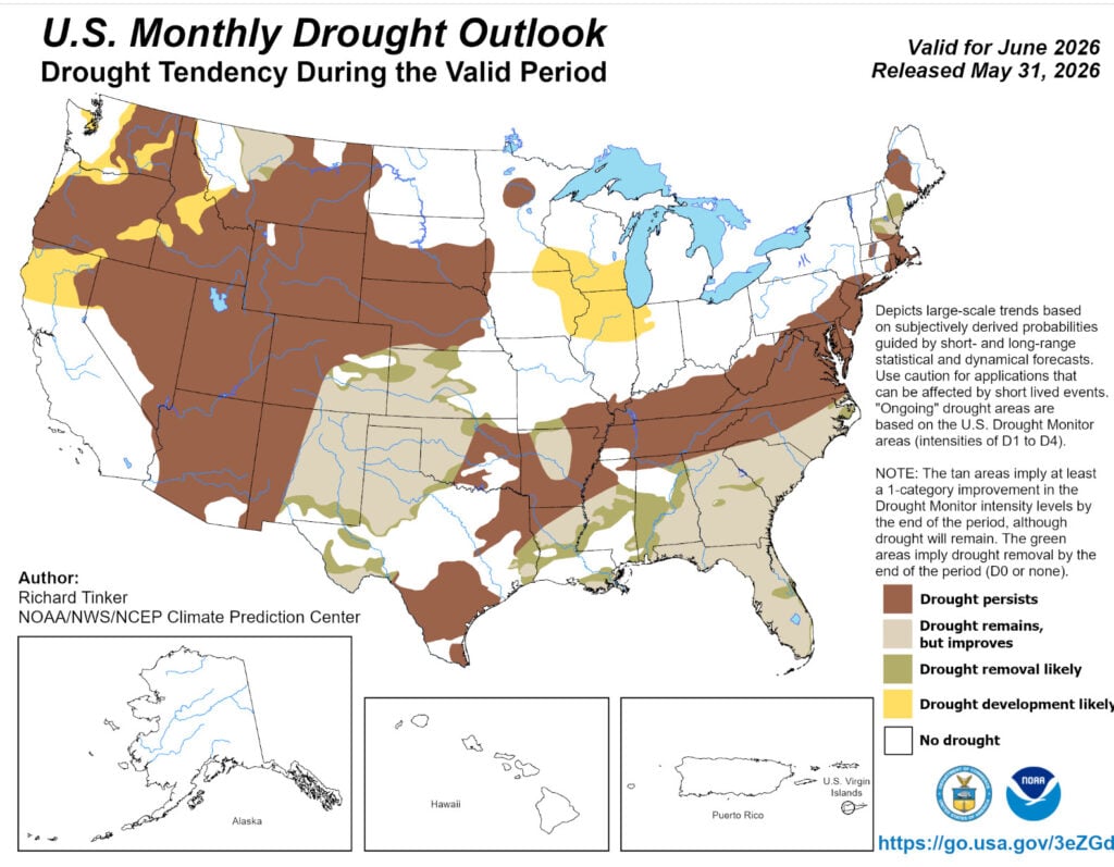
The map clearly illustrates the vast geographical footprint of the current drought, showing persistent dry conditions locked over the mountain West and extending aggressively into the agricultural corridors of the central United States.
The following data tracks the cumulative percentage area of selected states experiencing extreme drought conditions, highlighting the sudden and severe shift from the same period in 2025:
| State | Extreme Drought Today (June 16, 2026) | One Year Ago (June 17, 2025) | Net Change |
| Nebraska | 50% | 0% | +50% |
| Wyoming | 41% | 0% | +41% |
| Colorado | 35% | 5% | +30% |
| Oklahoma | 30% | 0% | +30% |
This massive surge in extreme dryness over just a single year indicates that the topsoil moisture has been completely depleted across millions of acres of prime agricultural territory.
Rain Gauges Running Dry Across the Midwest
The crisis is further underscored by analyzing year-to-date precipitation actuals against long-term historical averages. Across major urban centers and agricultural hubs in these affected states, moisture deficits have grown into deep, multi-inch chasms. Key growing areas are seeing rainfall amounts plummet by 40% or more below normal levels, actively threatening crop development for the current season.
| City | 2026 Precipitation YTD (Actual) | Avg. Annual Precipitation YTD | YTD Variance & Percentage Decrease |
| Cheyenne, WY | 3.87” | 7.42” | -3.55” / -48% |
| Kearney, NE | 6.41” | 12.03” | -5.62” / -46% |
| Oklahoma City, OK | 9.77” | 16.92” | -7.15” / -42% |
| Denver, CO | 4.02” | 6.66” | -2.64” / -40% |
“Here we are before El Niño is really getting going, and many areas of the country are already experiencing drought,” warned AccuWeather Founder and Executive Chair Dr. Joel N. Myers. When analyzing these numbers on a national scale, the sheer scope of the dryness becomes historically significant. Dr. Myers explained that “when you average the rainfall across the country and give equal weight to all parts of the nation, you are talking about a level of dryness that occurs in less than 5% of the historical record. That is less than one in 20 years on average.”
The baseline dryness means there is no margin for error. As the Super El Niño develops, the risk is that these deficits will multiply exponentially. “There is real concern the drought conditions could worsen as the precipitation deficit grows, given the expected strength of El Niño,” Dr. Myers added. While isolated parts of the deep South remain highly saturated and states like Utah, Idaho, Virginia, and North Carolina see fluctuating conditions, the core production zones of the American breadbasket are drying out.
The Specter of a ‘Mini-Dust Bowl’
The compounding effect of an existing drought colliding with a Super El Niño has led climate researchers to evaluate some of the darkest chapters in American environmental history. Specifically, experts are raising the possibility of a modern mini-Dust Bowl taking root in the central states over the next few years.
When a severe drought sets in a region, it can alter local thermodynamics, creating a self-perpetuating feedback loop. During the infamous Dust Bowl of the 1930s, a prolonged period of heat thoroughly baked the soil. Because the ground held virtually no moisture, localized evaporation halted, cutting off the primary fuel needed to create afternoon thunderstorms.
“This cycle of drought, heat, drought, heat, extreme dryness, record high temperatures, and so on matters. Despite global warming that is occurring, the record high temperatures for many states still stand from the 1930s, 90 years ago.”
— Dr. Joel N. Myers, Invisible Iceberg: When Climate and Weather Shaped History (2024)
This runaway loop operates on a micro-physical level within the atmosphere. In dry soil environments, wind currents kick substantial amounts of fine dust particles into the air. When moisture does manage to ascend, it encounters an overabundance of these dust particles competing to act as condensation nuclei. As a result, clouds produce an immense number of microscopic water droplets that are simply too light to overcome atmospheric updrafts. They fail to fall as rain, evaporating back into the upper atmosphere and leaving the parched soil below completely unrewarded.
“You get more water droplets that are smaller and have trouble falling out of the clouds, so you get less rain,” Dr. Myers stated during a presentation of AccuWeather‘s groundbreaking climate trends study. “Less rain means drier and hotter soil which brings drought and drought brings heat and you have a cycle that is running away. That is the concern.”
Economic and Agricultural Ramifications
The structural differences between modern agricultural infrastructure and 1930s practices mean a full-scale environmental collapse of that era’s proportions is highly unlikely. “We are not predicting a Dust Bowl, which was disastrous during the 1930s, to occur now because there were poor farming practices back then and other things that we do better today,” Dr. Myers clarified. “But we are taking the situation we are experiencing today very seriously.”
Even without the literal black blizzards of topsoil that defined the 1930s, a localized “mini-Dust Bowl” would trigger profound economic shocks. Staple crops like soybeans and corn will face severe physiological stress in the fields. If yields collapse across the Plains over consecutive seasons, the downstream effects will manifest rapidly as food price inflation at the grocery store. Beyond the agricultural sector, urban centers reliant on the Colorado River basin and major aquifers will face unprecedented strain on their drinking water infrastructure.
Earlier this year, AccuWeather climate experts released a comprehensive study analyzing these multi-decade atmospheric shifts across the contiguous United States. The conclusions are unmistakable: if these current climate and precipitation trends persist, they will introduce severe, long-term disruptions to the broader U.S. economy, energy grid stability, and consumer food security. With a 70% chance of a Super El Niño accelerating these baseline vulnerabilities, the coming months will be critical for agricultural producers and water managers preparing for a dry and challenging road ahead.
Sources and Lnks:
- AccuWeather Official Portal
- U.S. Drought Monitor Map and Data Archive
- National Centers for Environmental Information – NOAA
- Invisible Iceberg: When Climate and Weather Shaped History (2024) by Dr. Joel N. Myers
Disclaimer
Artificial Intelligence Disclosure & Legal Disclaimer
AI Content Policy.
To provide our readers with timely and comprehensive coverage, South Florida Reporter uses artificial intelligence (AI) to assist in producing certain articles and visual content.
Articles: AI may be used to assist in research, structural drafting, or data analysis. All AI-assisted text is reviewed and edited by our team to ensure accuracy and adherence to our editorial standards.
Images: Any imagery generated or significantly altered by AI is clearly marked with a disclaimer or watermark to distinguish it from traditional photography or editorial illustrations.
General Disclaimer
The information contained in South Florida Reporter is for general information purposes only.
South Florida Reporter assumes no responsibility for errors or omissions in the contents of the Service. In no event shall South Florida Reporter be liable for any special, direct, indirect, consequential, or incidental damages or any damages whatsoever, whether in an action of contract, negligence or other tort, arising out of or in connection with the use of the Service or the contents of the Service.
The Company reserves the right to make additions, deletions, or modifications to the contents of the Service at any time without prior notice. The Company does not warrant that the Service is free of viruses or other harmful components.


")


