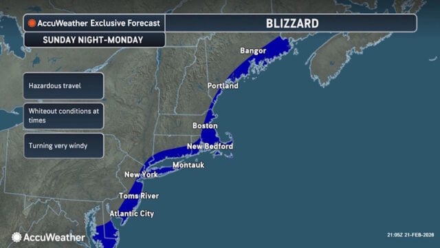
These are the expected snowfall amounts as of this morning
AccuWeather expert meteorologists are on duty and available for interviews on the forecast for a major nor’easter with blizzard conditions set to impact cities across the Northeast:
- 18-24 inches: Parts of Long Island and the Cape
- 12-18 inches: Boston
- 10-14 inches: New York City and Philadelphia
- 3-6 inches: Baltimore
- 1-3 inches: Washington, D.C.
- * AccuWeather Forecast as of 8 am ET
The Northeast is currently under siege from a relentless winter pattern that refuses to break. For the fifth consecutive weekend, residents from West Virginia to Maine are preparing for accumulating snowfall as a powerful nor’easter rapidly intensifies off the Atlantic coast. This latest system threatens to be the most “dangerous and incredibly disruptive” of the season, according to meteorologists, with the potential to bring blizzard conditions to some of the nation’s most densely populated hubs.
The Anatomy of a “Bombing” Nor’easter
The storm is expected to begin its trek Saturday night, spreading a swath of white from the Appalachian ridges toward the coast. However, the real danger lies in the storm’s rapid intensification—a process often called “bombogenesis”—expected on Sunday. As the storm’s central pressure drops precipitously, it will act like a vacuum, pulling in moisture from the relatively warm Atlantic and colliding it with a lingering Arctic air mass.
This collision will result in snowfall rates of 1 to 2 inches per hour and wind gusts exceeding 50 mph from Sunday night into early Monday morning.
“The combination of heavy snow and powerful wind gusts could create blizzard conditions from the Jersey Shore and Long Island up to the New England coast,” AccuWeather Director of Forecasting Operations Carl Erickson said. “Blizzard conditions may reach parts of New York City and Boston. This will be a dangerous and incredibly disruptive winter storm.”
Snowfall Totals: A Tale of the Tape
The I-95 corridor, the backbone of Northeast transit, sits directly in the crosshairs. While the exact “wobble” of the storm will determine final totals, current projections suggest a significant impact for major metropolitan areas.
| Region/City | Forecasted Snow Accumulation |
| Long Island & The Cape | 12–18 inches |
| Boston | 8–12 inches |
| New York City & Philadelphia | 6–10 inches |
| Baltimore | 3–6 inches |
| Washington, D.C. | 1–3 inches |
For New York City, this storm is a statistical tipping point. The city has already recorded 22.3 inches of snow this season, nudging it just past the historical average of 22.1 inches. After a brutal stretch of cold where temperatures plummeted nearly 10 degrees below the historical average, this nor’easter serves as a capstone to a punishing winter month.
A Transportation Nightmare
The timing of the storm—hitting late Sunday and lingering into the Monday morning commute—is a worst-case scenario for regional transit. AccuWeather experts are forecasting a cascade of cancellations across the aviation sector, estimating more than 1,000 flight cancellations on Sunday and an additional 1,500 on Monday.
Carl Erickson warned that the danger on the ground might even exceed the chaos in the air. “Travel will be treacherous, if not impossible, during the worst of the storm,” Erickson noted. “Blowing snow with near-zero visibility will make travel on the highways incredibly dangerous. People attempting to drive through this nor’easter could end up stranded for hours.”
Rail services, including Amtrak’s Northeast Corridor, are expected to see significant delays or suspensions as crews struggle to keep tracks clear of drifting snow and fallen debris.
Coastal Risks and Infrastructure Strain
Beyond the snow, the “Nor” in Nor’easter refers to the powerful northeasterly winds that will lash the coastline. Areas from the Delmarva Peninsula up to Cape Cod face a triple threat: high waves, significant beach erosion, and the risk of coastal flooding during high tide cycles.
Infrastructure is also at risk. The combination of heavy, wet snow at the onset of the storm followed by high-velocity wind gusts is a recipe for power outages. Utility companies across the region have already begun pre-positioning crews, but the “blizzard conditions” mentioned by Erickson could make it difficult for bucket trucks to reach damaged lines until the winds subside on Monday afternoon.
The “Wobble” Factor
Forecasting a nor’easter is a game of miles. Erickson explained that the storm’s exact track remains the most critical variable. “A small wobble in the storm track can make a big difference,” he said. “If the center comes a bit closer to the coast, heavier snow bands and stronger winds can shift inland. If the storm tracks farther offshore, some inland locations will end up with less snow, but the immediate coast can still get hit hard.”
The Economic Toll of a Relentless Winter
This weekend’s storm is more than just a meteorological event; it is an economic burden. This marks the fifth weekend in a row with accumulating snow for several cities. These back-to-back storms have triggered a surge in heating bills and costly shutdowns for small businesses and school districts.
As the storm moves out late Monday, it will leave behind a deep freeze, keeping the snow on the ground for days to come. For the millions of residents in the storm’s path, the message is clear: finish your preparations by Saturday afternoon and prepare to hunker down.
Sources and Links
- AccuWeather: Rapidly Strengthening Nor’easter to Lash Northeast
- National Weather Service (NWS): Winter Storm Watches and Warnings
- FlightAware: Misery Map – Real-time Flight Cancellations
- NYC Emergency Management: Winter Weather Updates and Safety Tips
- U.S. Department of Transportation: Winter Weather Driving Safety
Disclaimer
Artificial Intelligence Disclosure & Legal Disclaimer
AI Content Policy.
To provide our readers with timely and comprehensive coverage, South Florida Reporter uses artificial intelligence (AI) to assist in producing certain articles and visual content.
Articles: AI may be used to assist in research, structural drafting, or data analysis. All AI-assisted text is reviewed and edited by our team to ensure accuracy and adherence to our editorial standards.
Images: Any imagery generated or significantly altered by AI is clearly marked with a disclaimer or watermark to distinguish it from traditional photography or editorial illustrations.
General Disclaimer
The information contained in South Florida Reporter is for general information purposes only.
South Florida Reporter assumes no responsibility for errors or omissions in the contents of the Service. In no event shall South Florida Reporter be liable for any special, direct, indirect, consequential, or incidental damages or any damages whatsoever, whether in an action of contract, negligence or other tort, arising out of or in connection with the use of the Service or the contents of the Service.
The Company reserves the right to make additions, deletions, or modifications to the contents of the Service at any time without prior notice. The Company does not warrant that the Service is free of viruses or other harmful components.


