For millions of Americans living in the eastern half of the country, the start of 2026 has felt like an endless gauntlet of sub-zero wind chills, record-breaking snowfall, and astronomical heating bills. From the catastrophic “Winter Storm Fern” in late January to the relentless train of Arctic clippers that followed, the season has been defined by its unforgiving brutality. However, meteorologists are now pointing to a significant shift in the atmospheric machinery. As we move through the second and third weeks of February, the icy iron curtain that has draped itself over the Northeast and Midwest is finally set to lift.
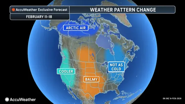
According to a recent report from AccuWeather, the frigid air that has dominated eastern North America is expected to retreat toward the Arctic Circle, making way for a much-needed, albeit complex, warmup.
A Gradual Exit for the Cold
The transition will not be instantaneous. Because of the sheer volume of snow currently on the ground and the thick ice covering lakes and rivers, the “cold dome” has a level of thermal inertia that takes time to overcome. “The last blast of Arctic air in the long train of cold waves will cycle through the Northeast into Monday,” AccuWeather senior meteorologist Alex Sosnowski noted. He explained that as this final surge departs, warmer air already building across the Western states and High Plains will begin its eastward trek.
However, the warmup faces an uphill battle. Snow-covered ground reflects sunlight rather than absorbing it, and frozen bodies of water act as a natural refrigerator, cooling the air immediately above them. Without the help of powerful, scouring winds, the initial stages of this thaw will be a slow, “gradual process,” Sosnowski says.
During the middle and latter parts of this week, residents can expect more afternoons where the mercury climbs near or slightly above the freezing mark. While 32 degrees Fahrenheit might not sound like “spring,” the combination of the strengthening February sun and a lack of biting wind will make a noticeable difference. The relentless buildup of ice on major waterways is expected to halt, and for the first time in weeks, the sound of dripping eaves will replace the howl of the wind.
The Numbers: From Single Digits to the 50s
The scale of the temperature recovery is impressive. In cities like Chicago, where residents have endured a “long, cold, and expensive winter,” the relief will be palpable. AccuWeather projections suggest that Chicago could see temperatures reach the lower 40s by Tuesday—its highest mark since mid-January. Further south, the rebound will be even more dramatic. Atlanta, which has shivered through an unusually cold start to the year, is forecast to hit the 70-degree mark for the first time in a month.
As the snowpack thins and the dark ground is revealed, the feedback loop of cold will break. This will allow temperatures in the Northeast and Midwest to jump into the 30s, 40s, and even into the 50s. “Even where temperatures recover to the 30s and low 40s, it will feel substantially warmer after highs in the single digits, teens, and 20s,” Sosnowski remarked. Along the Atlantic Coast, the infusion of southern Plains air could push highs into the 60s and 70s by the third week of the month.
The Hidden Hazards of a Pattern Change
While the retreating cold is welcome news for those struggling with high energy costs—which AccuWeather Chief Meteorologist Jonathan Porter recently noted have placed a “significant strain on many people’s budgets”—the transition brings its own set of meteorological headaches.
The incoming air mass originates from the Pacific, meaning it carries significantly more moisture than the bone-dry Arctic air it replaces. When this moist air meets the lingering cold at the surface, it often creates a recipe for “wintry precipitation.” AccuWeather warns that even though thermometer readings will be higher, they may still hover in the critical zone where snow, sleet, or freezing rain can develop.
Furthermore, the temperature swing creates a “freeze-thaw” cycle that is notoriously dangerous for travel. Runoff from melting snow during the sunny daylight hours can easily refreeze into “black ice” once the sun sets, turning seemingly clear roads into skating rinks. Additionally, the clash of mild air over cold ground often results in dense, widespread fog, which can lead to significant delays at major travel hubs and on interstates.
Economic Relief and Long-Term Outlook
The timing of this “pull back” is critical. Earlier this month, AccuWeather analyzed the economic impact of the 2025–26 winter season, estimating that the combination of “bomb cyclones,” deep freezes, and infrastructure damage has already resulted in economic losses between $13 billion and $15 billion. The strain on the power grid has been immense, with more than a million customers losing power during recent events.
During February 17–20, much of the eastern U.S. is expected to experience its warmest conditions in over a month. This window of mild weather will provide utility companies a chance to repair damaged infrastructure and homeowners a reprieve from the “relentless and dangerous” stretch of heating demand.
However, experts caution that a February thaw does not necessarily mean winter is over. The polar vortex, while retreating for now, remains a volatile player. Past years have shown that a mid-February warmup can often be followed by a “March surprise.” For now, though, the focus is on the immediate future: a week where gloves might finally stay in pockets, and the “Arctic Circle” air returns to where it belongs.
As the nation enters the third week of February, the maps are finally losing their deep-blue hues. While the threat of ice and fog remains, the sheer intensity of the “Permanent Siberia” feel of January is fading. For a weary public, the forecast of 40 degrees has never looked so good.
Source: AccuWeather
Disclaimer
Artificial Intelligence Disclosure & Legal Disclaimer
AI Content Policy.
To provide our readers with timely and comprehensive coverage, South Florida Reporter uses artificial intelligence (AI) to assist in producing certain articles and visual content.
Articles: AI may be used to assist in research, structural drafting, or data analysis. All AI-assisted text is reviewed and edited by our team to ensure accuracy and adherence to our editorial standards.
Images: Any imagery generated or significantly altered by AI is clearly marked with a disclaimer or watermark to distinguish it from traditional photography or editorial illustrations.
General Disclaimer
The information contained in South Florida Reporter is for general information purposes only.
South Florida Reporter assumes no responsibility for errors or omissions in the contents of the Service. In no event shall South Florida Reporter be liable for any special, direct, indirect, consequential, or incidental damages or any damages whatsoever, whether in an action of contract, negligence or other tort, arising out of or in connection with the use of the Service or the contents of the Service.
The Company reserves the right to make additions, deletions, or modifications to the contents of the Service at any time without prior notice. The Company does not warrant that the Service is free of viruses or other harmful components.


