The Northeast is bracing for its most significant atmospheric assault of the season as a massive surge of Arctic air prepares to plunge the region into a deep freeze. Affecting more than 100 million people, this weekend will deliver a brutal combination of accumulating snow, rapid freeze-ups, and life-threatening wind chills that will paralyze travel and strain infrastructure from Friday through Sunday.
Arctic Arrival: Timing the Deep Freeze
The transition from a standard winter chill to a historic Arctic outbreak begins in earnest on Friday. A potent cold front will sweep from the Great Lakes into the Appalachians, serving as the leading edge of a polar air mass.
While Friday will see the initial arrival of the cold, Saturday is forecast to be the “core” of the event. Meteorologists warn that the temperature drop will be exceptionally rapid—a phenomenon known as a “flash freeze”—turning slush and wet pavement into sheets of ice within minutes of the front’s passage.
Snowfall Focus: Where the Flakes Will Fly
The storm system will be a “two-act” play of precipitation.
- Act One (Friday): Snow will pivot through the Great Lakes and the west-facing slopes of the Appalachians. Residents in these areas should prepare for 1–3 inches of accumulation, often accompanied by blinding squalls.
- Act Two (Saturday): A developing storm along the Arctic front will focus its energy on southern and central New England.
“It’s possible there’s a narrow zone where 4–5 inches of snow falls over southern and central New England on Saturday,” says Bernie Rayno, AccuWeather Chief On-Air Meteorologist.
While the mid-Atlantic and areas east of the Appalachians may only see brief snow showers or a dusting, the intense cold behind the front will be the universal story.
City-Specific Timelines
- Detroit: Snow begins late Thursday night, continuing into Friday afternoon. A rapid temperature drop Friday evening will freeze any standing water or slush.
- New York City: Snow is expected Friday evening into early Saturday. Temperatures will plummet into the teens on Saturday, with single-digit lows overnight.
- Boston: The heaviest impact arrives late Friday night into Saturday. Bostonians should prepare for plowable snow followed by Saturday night temperatures bottoming out near zero.
Dangerously Low RealFeel Temperatures
The actual air temperature is only half the story. A powerful pressure gradient will generate north-northwest winds gusting between 35 and 55 mph.
“Not only will the air temperature plummet after the Arctic front moves through, but north-northwest winds… will also occur, resulting in AccuWeather RealFeel® Temperatures falling to dangerously low levels,” warns AccuWeather Meteorologist Brandon Buckingham.
In many rural and mountain areas, wind chills could dive to between -20°F and -35°F. At these levels, frostbite can occur on exposed skin in as little as 10 to 30 minutes.
Business and Infrastructure Disruptions
The combination of snow and extreme cold creates high operational risks. Major hubs like Logan International in Boston and the airports in the NYC area are likely to see significant flight delays and cancellations. On the ground, road crews will face challenges as road salt becomes less effective at temperatures below 15°F.
Energy grids will also face a major test as heating demand spikes to seasonal highs. Logistics managers should note that the “slippery travel” threat may re-emerge Sunday night into Monday across the Ohio Valley as a secondary, weaker system moves in.
Looking Ahead: A Mid-February Thaw?
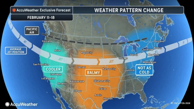
There is a light at the end of the freezer. Long-range forecasts suggest that this Arctic surge will be the “peak” of the winter’s cold. By the second week of February, a shift in the polar vortex and the jet stream will allow milder Pacific air to flood eastward.
While the warming trend will be uneven—hindered in areas with deep snow cover—temperatures in the Midwest and Northeast are expected to rebound from the single digits into the 30s, 40s, and even near 50 degrees by mid-month. However, residents are urged not to let their guard down yet; the transition from deep freeze to thaw often brings its own set of hazards, including ice jams and localized flooding.
Source: AccuWeather
Disclaimer
Artificial Intelligence Disclosure & Legal Disclaimer
AI Content Policy.
To provide our readers with timely and comprehensive coverage, South Florida Reporter uses artificial intelligence (AI) to assist in producing certain articles and visual content.
Articles: AI may be used to assist in research, structural drafting, or data analysis. All AI-assisted text is reviewed and edited by our team to ensure accuracy and adherence to our editorial standards.
Images: Any imagery generated or significantly altered by AI is clearly marked with a disclaimer or watermark to distinguish it from traditional photography or editorial illustrations.
General Disclaimer
The information contained in South Florida Reporter is for general information purposes only.
South Florida Reporter assumes no responsibility for errors or omissions in the contents of the Service. In no event shall South Florida Reporter be liable for any special, direct, indirect, consequential, or incidental damages or any damages whatsoever, whether in an action of contract, negligence or other tort, arising out of or in connection with the use of the Service or the contents of the Service.
The Company reserves the right to make additions, deletions, or modifications to the contents of the Service at any time without prior notice. The Company does not warrant that the Service is free of viruses or other harmful components.


