

The eastern half of the United States is bracing for a punishing stretch of winter weather as a major disruption of the polar vortex locks a frigid pattern in place through at least mid-February. Following a massive “bomb cyclone” that recently hammered the Southeast, meteorologists warn that the reprieve will be short-lived. A series of fast-moving storm systems and a reinforcing arctic front are set to deliver a combination of snow, ice, and life-threatening cold from the Midwest to the Atlantic Seaboard.
Mid-Week Snow Threat for the Mid-Atlantic
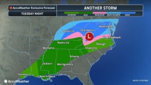 The first of several disturbances is already underway. A moisture-starved but potent system is expected to spread a coating of snow from southern Illinois through the central Appalachians and into the Mid-Atlantic. While not a blockbuster storm, its timing—late Tuesday night into Wednesday morning—poses a significant risk for commuters.
“A storm moving into the cold air in western Tennessee on Tuesday is expected to move east towards the Virginia coast into Wednesday, bringing a quick-hitting bout of snow,” said AccuWeather Senior Meteorologist Tyler Roys.
Major metropolitan areas along the I-95 corridor are in the crosshairs for light accumulations. According to Roys, “Cities like Washington, D.C., or Baltimore could see upwards of an inch late Tuesday night into Wednesday morning, and even a stripe of snow that tries to make it to the Eastern Shore of Maryland.”

As the system shifts south on Wednesday night, the precipitation profile will become more complex. Residents in southern Virginia and northern North Carolina should prepare for a messy mix of rain, snow, and sleet. Forecasters are particularly concerned about a window of freezing rain across North Carolina on Wednesday night, which could create a “glaze” on roads, making travel treacherous for the Thursday morning commute.
Brief Relief in the South
South of the freezing line, a transient “warm-up” will offer a temporary break for those weary of the cold. Highs near 50 degrees Fahrenheit are forecast for Nashville and Raleigh, providing a stark contrast to the sub-freezing temperatures of previous days.
“Ahead of the rain will be a brief uptick in temperature, bringing a welcome break from the cold for many,” Roys noted, adding that “the warmer air, in addition to the rain, should help to melt the snow across the southern Appalachians and Carolinas.”
Arctic Front and Dangerous Snow Squalls
 The reprieve will be fleeting. By Friday, an intense arctic front is forecast to sweep from the Great Lakes into New England. This front will not only bring another surge of extreme cold but also the threat of dangerous snow squalls. Unlike steady snowstorms, squalls are characterized by intense bursts of heavy snow and localized whiteout conditions that can catch drivers off guard.
“Snow showers and snow squalls are going to accompany the arctic cold front as it traverses the Northeast on Friday,” warned AccuWeather Meteorologist Peyton Simmers. “These snow showers and squalls can limit visibility and lead to roads becoming snow-covered and icy quickly.”
Behind this front, the mercury will plummet. Wind gusts of 30–55 mph will likely lash the Northeast by Saturday, pushing AccuWeather RealFeel® Temperatures to between 10 and 30 degrees below zero in the coldest spots.
The Polar Vortex: Why the Cold Won’t Quit
The underlying cause of this relentless winter is a “collapse” or weakening of the polar vortex. Typically, this band of strong winds keeps frigid air bottled up at the poles. However, recent stratospheric warming has caused the vortex to wobble and “split,” allowing lobes of arctic air to spill southward into the lower 48 states.
This pattern is expected to persist through mid-February, keeping monthly temperatures 5–10 degrees below historical averages for much of the East. The presence of extensive snow cover and growing ice on the Great Lakes will further “insulate” the cold air, preventing it from moderating as it moves south.
Business and Infrastructure Impacts
The prolonged nature of this cold snap is more than just a nuisance; it is an operational hazard. “Another reinforcing shot of arctic air is expected to send temperatures plummeting back down into the single digits overnight into this weekend,” Simmers stated.
The impacts are expected to be widespread:
- Energy Demand: Sustained freezing temperatures will keep heating demand at peak levels, straining power grids.
- Infrastructure: The risk of pipe bursts remains high. Simmers advises that “protective measures” should be taken immediately.
- Safety: With wind chills dropping well below zero, the risk of frostbite on exposed skin can occur in as little as 30 minutes.
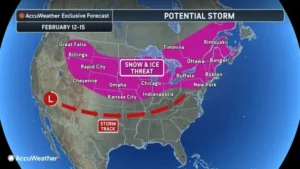
Meteorologists are also keeping a close eye on the window of February 12–15, where a more substantial storm system could potentially bring heavy snow and ice from the northern Plains to the Northeast. For now, residents are urged to maintain full heating-fuel tanks and prepare for a month that appears determined to keep the Eastern U.S. in a deep freeze.
Disclaimer
Artificial Intelligence Disclosure & Legal Disclaimer
AI Content Policy.
To provide our readers with timely and comprehensive coverage, South Florida Reporter uses artificial intelligence (AI) to assist in producing certain articles and visual content.
Articles: AI may be used to assist in research, structural drafting, or data analysis. All AI-assisted text is reviewed and edited by our team to ensure accuracy and adherence to our editorial standards.
Images: Any imagery generated or significantly altered by AI is clearly marked with a disclaimer or watermark to distinguish it from traditional photography or editorial illustrations.
General Disclaimer
The information contained in South Florida Reporter is for general information purposes only.
South Florida Reporter assumes no responsibility for errors or omissions in the contents of the Service. In no event shall South Florida Reporter be liable for any special, direct, indirect, consequential, or incidental damages or any damages whatsoever, whether in an action of contract, negligence or other tort, arising out of or in connection with the use of the Service or the contents of the Service.
The Company reserves the right to make additions, deletions, or modifications to the contents of the Service at any time without prior notice. The Company does not warrant that the Service is free of viruses or other harmful components.
")
")


")
")
