The Sunshine State is currently enduring one of its most intense winter periods in years. As a powerful Arctic high-pressure system settles over the Southeast, Florida is experiencing temperatures that rival northern latitudes.1 This extreme cold is not just a brief snap but a prolonged event that has triggered hard freeze warnings for 55 of Florida’s 67 counties.
A Historic Chance of Snow
The most unusual aspect of this weekend’s forecast is the potential for a wintry mix or rare snowflakes in the Panhandle. A fast-moving storm system tracking across the Deep South late Saturday into Sunday is expected to collide with the Arctic air entrenched over the state.
- The Panhandle & I-10 Corridor: Cities from Pensacola to Tallahassee are monitoring a 20–30% chance of snow flurries or light freezing rain early Sunday morning. While most areas will see cold rain, any intrusion of moisture before the air warms could lead to the region’s first measurable snow in years.
- Central & South Florida: While snow is not expected farther south, a cold air surge on Sunday night will keep temperatures well below seasonal averages through Martin Luther King Jr. Day.
Florida Temperature Outlook
Temperatures are forecast to plummet 15 to 20 degrees below normal. North Florida will see the most dangerous cold, with lows in the 20s potentially lasting over four hours, threatening plumbing and crops.
| City | Sat Night Low | Sun Night Low | Mon (MLK Day) High |
| Tallahassee | 41°F | 27°F | 58°F |
| Jacksonville | 46°F | 29°F | 55°F |
| Orlando | 45°F | 39°F | 60°F |
| Tampa | 57°F | 39°F | 58°F |
| Miami | 61°F | 49°F | 68°F |
The National Picture: A Relentless Arctic Pattern
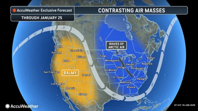
While Florida monitors rare flurries, the rest of the Central and Eastern U.S. remains locked in a persistent cold-weather pattern. This setup is driven by a highly active polar vortex, which has carved a deep trough across the eastern two-thirds of North America. This “atmospheric conveyor belt” is ushering in repeated surges of Arctic air and fast-moving “clipper” storms through at least early next week.
Great Lakes and Northeast: Cumulative Impacts
For the Great Lakes and the interior Northeast, the story is one of persistence. Clipper storms, though often light in moisture, are tracking with high frequency. One system exited the Northeast Thursday night, only to be followed by another moving through the Upper Midwest on Friday. Behind these clippers, the “lake-effect machine” has shifted into high gear.
The most significant snow totals are reserved for the snow belts downwind of Lakes Erie, Ontario, and Michigan. In Western New York and parts of Michigan, where moisture from the relatively warm lake waters meets the frigid Arctic air, totals are expected to reach 12 to 24 inches by Tuesday morning.
The Mid-Atlantic and East Coast: A “Developing” Threat
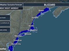
Further south, a developing coastal storm is forecast to bring a band of snow from the Carolinas through Virginia on Sunday before tracking northward. While this is not expected to be a major Nor’easter, even a coating to an inch in cities like Raleigh or Richmond can paralyze local infrastructure. Along the I-95 corridor from Philadelphia to Boston, the storm may bring a “burst” of snow Sunday night into Monday morning, potentially complicating the first commute of the new week.
Snowfall Totals Forecast (Jan 16–20)
As these systems interact, the cumulative snowfall will vary wildly based on terrain and proximity to the Great Lakes.
| Metro Area/Region | Expected Snow Total (Cumulative) | Primary Driver |
| Buffalo, NY | 18–24″ | Lake-Effect / Multi-system |
| Grand Rapids, MI | 8–12″ | Lake-Effect / Clippers |
| Pittsburgh (Seven Springs) | 5–8″ | Upslope Snow / Arctic Front |
| Minneapolis, MN | 3–6″ | Frequent Clippers |
| Boston, MA | 2–4″ | Coastal Storm / Light Flurries |
| Detroit, MI | 2–4″ | Clippers / Light Lake-Effect |
| Chicago, IL | 1–3″ | Light Clippers |
| Charlotte, NC | Coating to 1″ | Sunday Coastal Storm |
| Tallahassee, FL | Coating to Trace | Rare Sunday Flurries |
Business and Operational Impacts
The prolonged cold and recurring snow events present a multi-faceted risk to regional commerce and logistics.
- Transportation: Ground logistics across the Midwest and Northeast face hazardous travel. Rapidly changing visibility during lake-effect squalls and slippery roads increase the risk of accidents and supply chain delays.
- Aviation: Major hubs, including Chicago O’Hare, Detroit Metropolitan, and the NYC-area airports, should prepare for increased deicing operations. Flight delays are likely to ripple through the network as carriers manage these winter operations.
- Energy: Colder-than-average conditions from the Plains to the East Coast are driving significant spikes in energy demand. Infrastructure in the South, less accustomed to sustained freezes, may face increased strain on power grids.
- Agriculture: In Florida and the Deep South, the threat to specialty crops remains high. Farmers are in “protection mode,” utilizing irrigation and heaters to safeguard citrus and vegetables from the hard freeze expected Sunday and Monday nights.
Looking Ahead: The Polar Vortex Signal
Long-range models suggest this is not a one-off event. The current pattern of fluctuating temperatures and periodic snow is expected to persist through the end of January. Meteorologists are watching for a potentially more significant cold blast or a “major” winter storm toward the final week of the month as the polar vortex continues to signal volatility.
Forecast information and graphics from AccuWeather
Disclaimer
Artificial Intelligence Disclosure & Legal Disclaimer
AI Content Policy.
To provide our readers with timely and comprehensive coverage, South Florida Reporter uses artificial intelligence (AI) to assist in producing certain articles and visual content.
Articles: AI may be used to assist in research, structural drafting, or data analysis. All AI-assisted text is reviewed and edited by our team to ensure accuracy and adherence to our editorial standards.
Images: Any imagery generated or significantly altered by AI is clearly marked with a disclaimer or watermark to distinguish it from traditional photography or editorial illustrations.
General Disclaimer
The information contained in South Florida Reporter is for general information purposes only.
South Florida Reporter assumes no responsibility for errors or omissions in the contents of the Service. In no event shall South Florida Reporter be liable for any special, direct, indirect, consequential, or incidental damages or any damages whatsoever, whether in an action of contract, negligence or other tort, arising out of or in connection with the use of the Service or the contents of the Service.
The Company reserves the right to make additions, deletions, or modifications to the contents of the Service at any time without prior notice. The Company does not warrant that the Service is free of viruses or other harmful components.


