Tuesday features mostly sunny skies around South Florida. The East Coast metro area will also see a few showers in spots, with gusty winds. A high risk of dangerous rip currents remains at the Atlantic beaches through at least Tuesday evening. Tuesday’s highs will be mainly in the upper-70s in the East Coast metro area and the Keys and in the low-80s along the Gulf Coast.
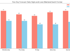
Wednesday will bring a mild morning, with lows in the 60s on the mainland. Then we’ll see a sunny day everywhere. A gusty ocean breeze continues in the East Coast metro area, so expect an elevated risk of dangerous rip currents at the Atlantic beaches. Christmas Eve will be clear and comfortable for both outdoor activities and Santa’s visit to South Florida. Wednesday’s highs will be near 80 degrees on the mainland and in the upper-70s in the Keys.
Christmas Day will feature the gift of good weather — a nice mix of sun and clouds in the East Coast metro area and sunny skies along the Gulf Coast and in the Keys. Thursday’s highs will be near 80 degrees in the East Coast metro area and in the upper-70s along the Gulf Coast and in the Keys.
Friday will start with mild morning lows in the 60s on the mainland. Then look for mostly sunny skies in the East Coast metro area, lots of sun along the Gulf Coast and in the Keys — and a few after-Christmas bargains if you’re ready for more shopping. Friday’s highs will be mainly in the low-80s on the East Coast and in the upper-70s along the Gulf Coast and the Keys.
Saturday’s forecast calls for morning lows in the 60s on the mainland, followed by a mix of sun and clouds in the East Coast metro area and the Keys. Look for sunny skies along the Gulf coast. Highs on Saturday will be in the low-80s in the East Coast metro area and the upper-70s along the Gulf Coast and the Keys.
Disclaimer
The information contained in South Florida Reporter is for general information purposes only.
The South Florida Reporter assumes no responsibility for errors or omissions in the contents of the Service.
In no event shall the South Florida Reporter be liable for any special, direct, indirect, consequential, or incidental damages or any damages whatsoever, whether in an action of contract, negligence or other tort, arising out of or in connection with the use of the Service or the contents of the Service.
The Company reserves the right to make additions, deletions, or modifications to the contents of the Service at any time without prior notice.
The Company does not warrant that the Service is free of viruses or other harmful components


