

Sunday features breezy conditions, a mix of sun and clouds, a few early storms, and some afternoon showers in the East Coast metro area. The Gulf Coast will see lots of sun, along with a few showers and storms on a brisk breeze in the afternoon. The Keys will be mostly sunny. A high risk of dangerous rip currents remains at the Atlantic beaches through Monday morning. Highs on Sunday will be in the mid-80s right at the Atlantic coast and in the Keys, in the upper 80s elsewhere in the East Coast metro area, and near 90 degrees along the Gulf Coast.
Monday will bring mostly sunny skies alternating with periods of showers in the East Coast metro area, while the Gulf Coast will be sunny with a few afternoon storms in spots. Look for good sun and a few clouds in the Keys. Expect an elevated risk of dangerous rip currents at the Atlantic beaches, especially along the Palm Beach County coast. Monday‘s highs will be in the upper 80s on the mainland and the mid-80s in the Keys.
Tuesday will feature mostly sunny skies and a few afternoon showers in the East Coast metro area. The Gulf Coast will see lots of sun and a few clouds at times, while the Keys will be mostly sunny. Tuesday‘s highs will be mostly in the mid-80s.
Wednesday will be mostly sunny with a few afternoon showers on a gusty breeze in the East Coast metro area as a weak front moves through. The Gulf Coast will be sunny with a brisk breeze, and the Keys will see mostly sunny skies. Wednesday‘s highs will be in the mid-80s on the mainland and the low-80s in the Keys.
Thursday‘s forecast calls for plenty of sun, a few clouds, and autumn-like temperatures. Highs on Thursday will be in the low 80s in the East Coast metro area and the upper 70s along the Gulf Coast and in the Keys.
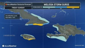
It looks increasingly likely that Hurricane Melissa will be a disaster of historic proportions for Jamaica and Haiti. Melissa is undergoing rapid intensification and is forecast to become a major hurricane on Sunday. Flooding and mudslides from several days of heavy rain will be made worse by major wind damage and storm surge in Jamaica and Hispaniola. Because steering currents have been weak and will be through Monday, heavy rain and destructive winds will be over the warning areas for extended periods of time. Similar hazards are expected in eastern Cuba on Tuesday and Wednesday, but Melissa will have weakened a bit from interaction with land, and its forward speed will increase.
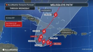 Melissa was located about 130 miles southeast of Kingston, Jamaica and 250 miles west-southwest of Port-au-Prince, Haiti early Saturday evening. Maximum sustained winds were 90 miles per hour at that time, and Melissa was moving west at 3 miles per hour. There is a hurricane warning for Jamaica, a hurricane watch for eastern Cuba, and a hurricane watch and tropical storm warning for Haiti from the border with the Dominican Republic to Port-au-Prince. Melissa will move to the northeast by Tuesday, and once it crosses Cuba on Tuesday into Wednesday, it will pose a threat to the Turks and Caicos and the southeastern Bahamas. The exact impacts on the southeastern Bahamas and the Turks and Caicos will depend on where the core area of hurricane force winds is at that time.
Disclaimer
Artificial Intelligence Disclosure & Legal Disclaimer
AI Content Policy.
To provide our readers with timely and comprehensive coverage, South Florida Reporter uses artificial intelligence (AI) to assist in producing certain articles and visual content.
Articles: AI may be used to assist in research, structural drafting, or data analysis. All AI-assisted text is reviewed and edited by our team to ensure accuracy and adherence to our editorial standards.
Images: Any imagery generated or significantly altered by AI is clearly marked with a disclaimer or watermark to distinguish it from traditional photography or editorial illustrations.
General Disclaimer
The information contained in South Florida Reporter is for general information purposes only.
South Florida Reporter assumes no responsibility for errors or omissions in the contents of the Service. In no event shall South Florida Reporter be liable for any special, direct, indirect, consequential, or incidental damages or any damages whatsoever, whether in an action of contract, negligence or other tort, arising out of or in connection with the use of the Service or the contents of the Service.
The Company reserves the right to make additions, deletions, or modifications to the contents of the Service at any time without prior notice. The Company does not warrant that the Service is free of viruses or other harmful components.


